I'm taking a break now, so I thought I'd post some more pictures of my recent trips to the southern reservoirs.
Last week at the Yanchao office, one of the engineers told me that I was wrong about what I thought had been the entry point for the diversion channel into Agongdian reservoir. My conjecture had been based on a roughly accurate idea of location relative to the geography of the reservoir and on observation of the recently constructed concrete channel through which a stream flows downhill. Apparently, this stream is unrelated to the reservoir but just happens to flow in a direction and area that would suggest otherwise, with the new concrete channel serving as a flood control measure. When I asked for pictures or plans of the diversion channel detailing the entry point and so on, I was told that was not possible since... me and my friend are just "normal people" without any formal affiliation to an academic or governmental office.
So on Tuesday, I cycled down to Agongdian reservoir and back to look for that entry point, since google earth proved to be useless for finding it. I had to ride around to the southern end into the farms that follow the two rivers back toward the volcanic hills. The total distance I did that day was 98K, and the 38K to arrive at the reservoir from Tainan city I completed in an hour and a half, rather than the two hours it had taken me the last time I did this trip - which is pretty good, and I climbed the hill I had been unable to climb last time too.
Myself amidst the farms to the south of Agongdian reservoir...

Agongdian reservoir (at the southern end) at sometime after 2pm - I was starting on my way back when I stopped for this parting shot, disappointed at having failed to find the diversion channel entry point. To the left is Xiaoganshan hill, with the larger Daganshan hill in the distance to the right...

On Wednesay morning I was up at 4am to drive to the back end of Tseng-wen reservoir on the big bike. Fantastic trip, but don't think I could manage it all the way there and back again on the bicycle yet. It's not just a question of distance, but of terrain: the road has a lot of steep, prolonged climbs and at the back end, when it is time to follow the river back up into Chiayi county's Alishan district, the road has a brutal stony surface with only occassional tarmac.
Fog all the way there, but once there the weather was fantastic and I was delighted to find that, unlike earlier this summer, the back end of the reservoir was full of water. Having walked along the reservoir bed previously, I could estimate the depth of the water at about ten meters - and maybe up to fifteen meters in the middle. Here is the back end of the reservoir at about 8am on Wednesday morning. The river enters the reservoir off to the right of the image where the sun peaks through the gap in the mountains...

Contrast that image with the one below. Note that the mountain visible on the left of the image above is the same peak to the right in the image below...

The cliff in the foreground of the latter image was almost entirely underwater on Wednesday morning, though I didn't photo it (I should have gone through my previous images the night before to look for images to repeat shoot and juxtapose).
My purpose in driving to Tseng-wen reservoir had been to follow the Tseng-wen river upstream. The size of the reservoir (12km from south to north, but an approximately 30km winding drive) means that there is so much of it to see and take in that even just looking around the southern part of it has tended to eat up all of my available time, meaning that despite many previous visits, I had never made it very far upstream before being recalled by life in Tainan city. So this was actually the first time I purposefully set out to simply go upstream. It was also the first time I tried using the black card technique for shots directly into bright sunlight, though I'm obviously going to need some more practice at it...

That image above shows the river running down from the mountains of Chiayi county's Alishan district. The sunlight really was much stronger than how it appears in that image, so I was at least partially successful in rendering the outline of the mountains without throwing the foreground into complete darkness.
Just across the bridge from where the above shot of the river was taken, the road splits left and right. Left is the normal road, but right is a steep, broken little mountain road following the course of the river up into the mountains of Alishan. And that's the road we took. A short while further on, we found the Cing Yun waterfall secluded from the brilliant sunlight in what would have to be judged a "nook or cranny" recess given the immense scale of the mountains...

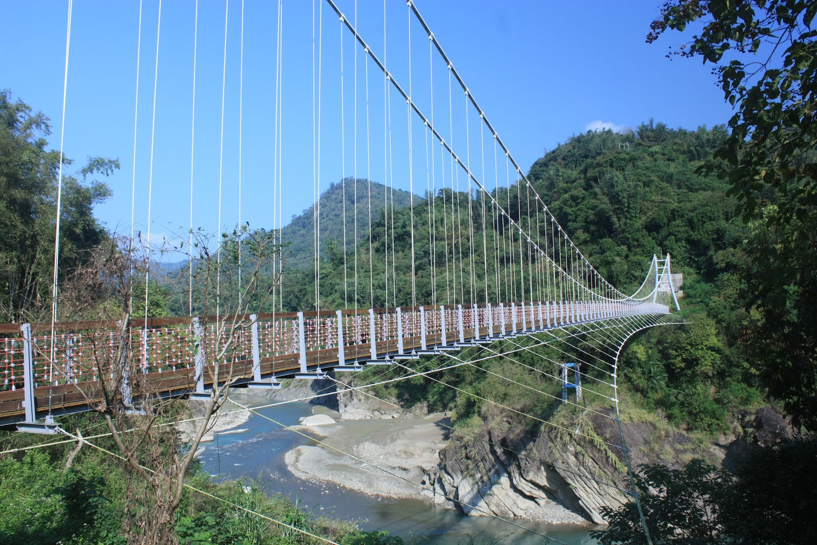
From there, we rounded a few more corners and approached the point overlooking what is a newly reconstructed suspension bridge (over the remains of its' predecessor)...
...and a truly massive weir...
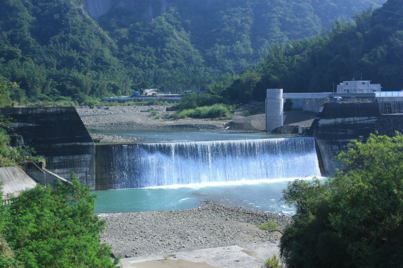
That weir is perhaps eight to ten meters tall; the tower just behind it on the right has a depth guage printed on it and is connected to a newly constructed monitoring station. I say "newly constructed", but whilst the building appears complete from the outside and still has its fresh white concrete, there is nobody there yet so obviously there is still work to be done on it.
Further along the road into Alishan district, and there were signs of construction for the Laonung river diversion (lots of excavators and backhoes at work), but we didn't stay long to take more photos because we wanted to get back to explore the weir, monitoring station and suspension bridge. By the time we had done that, it was already well after 10am, and there were appointments and such to keep back in Tainan city, one of which was to meet the landlord for the new place and sort out a contract.
The move to the new apartment will impose some extra, unwanted expense on me (hiring a truck to shift the furniture; paying rent in advance as well as two months deposit; paying for two sets of bills and all the cleaning and tidying up and packing that has to be done). It's going to be a pain in the neck, and will probably keep me from getting back out there for a while yet, but there's still a lot more work to do for three of the southern reservoirs: Tseng-wen, Baihe and Agongdian.
Eventually, however, I'll start looking north again.
No comments:
Post a Comment
Comment moderation is now in place, as of April 2012. Rules:
1) Be aware that your right to say what you want is circumscribed by my right of ownership here.
2) Make your comments relevant to the post to which they are attached.
3) Be careful what you presume: always be prepared to evince your point with logic and/or facts.
4) Do not transgress Blogger's rules regarding content, i.e. do not express hatred for other people on account of their ethnicity, age, gender, sexual orientation or nationality.
5) Remember that only the best are prepared to concede, and only the worst are prepared to smear.