

 Situated just outside the eastern administrative boundary of Chiayi city, Renyitan reservoir is fed by the Bazhang river (八掌溪) which begins approximately 25 kilometers away to the east high up in the mountainous area of Alishan (阿里山). Positioned between natural high ground to the north and the low-lying plains surrounding the Bazhang river (八掌溪) to the south, Renyitan reservoir is separated from its older and smaller neighbour, Lantan reservoir by a short distance of only two kilometers. Although a major freeway runs in between the two reservoirs, they are connected by an underground aqueduct which transfers water from Renyitan reservoir to its smaller neighbour. The reason for this is that Renyitan reservoir was built on the site of Lantan reservoir's previous water-intake conduit. With the growth of Chiayi city in the latter half of the twentieth century, the city's existing water supply system had become insufficient. Fed chiefly by two small rivers (the Bazhang to the south of the city and the Puzih to the north) with only the relatively tiny Lantan reservoir to help conserve water during the dry season, the city's growth meant that, without further investment in water conservation, the people of Chiayi would be facing the prospect of water-rationing. Constructed between 1980 and 1987, Renyitan reservoir fulfilled this immediate demand for further water conservation.
Geography Of Renyitan Reservoir


 On a clear day, after the rain has washed out the usual humidity-induced haze, the relative proximity of Renyitan reservoir to Taiwan's central mountain range becomes readily apparent and yet unlike other similarly positioned reservoirs which take advantage of a natural depression in the land between the foothills (such as Wushantou reservoir to the south), Renyitan is entirely man-made. However, although Renyitan is set within an excavated basin, the natural lie of the surrounding land follows the course of the nearby river in that it is higher to the east of the reservoir and lower to the west. This fact explains away an apparant paradox: to a naive observer the reservoir appears to sit at a higher elevation than the river from which it draws upon, but some distance further back to the east where the reservoir's intake channel is situated, the river's elevation is approximately level with that of the reservoir. As the river flows westward from this point, it rapidly descends over a staggered set of concrete weirs in a series of waterfalls and then continues to course westward on a downward slope such that, at the point where it runs parallel to the southern, horizontal stretch of the reservoir's dam, there may be a difference of as much as
 With a total capacity of 27.8 million cubic meters, and a surface area of just 2.11 square kilometers Renyitan reservoir is one of Taiwan's smallest reservoirs - though it is nontheless approximately three times larger than its older neighbour Lantan reservoir. Operating at 95% capacity with no major sedimentation or eutrophication problems; Renyitan is also one of Taiwan's healthiest reservoirs such that its' effective volume is just over 25 million cubic meters. The most obvious reason for its health is the fact that, unusually, Renyitan reservoir is not fed directly by its source, the Bazhang river, but indirectly by means of a weir and dam entrapment system which redirects a portion of the river's water flow through a filtration system and then on toward the reservoir itself. The weir is actually a set of concrete shelves down which the river, when full, falls from east to west with the entrapment dam on the northern side.

 A relatively small portion of the river's girth is blocked on the north-western corner of the weir by a set of large hydraulic gates which block the water's flow over the weir and thereby redirect it into a triangular entrapment pen sitting just in front of the gates. Although the entrance to the entrapment pen is divided into six grilled apertures, these do not appear to be gated in any form (although they are surmounted by what appears to be a sliding water gauge). Instead, there is a further hydraulic gate at the apex of the pen which dictates whether the water can pass through on its way to the reservoir. In the event of flooding, this gate would have to work in tandem with the gates on the north-western corner of the river's weir so as to prevent the river from breaching its banks and overwhelming the entrapment pen. A decision to close this gate at the apex of the pen would also need to be informed by the monitoring of the reservoir's water level so as to avoid any risk to the integrity of the dam. From the apex-gate of the entrapment pen the water flows on in a north-westerly direction toward the reservoir for a distance of 250 meters until it enters a six-channel filtration system, the purpose of which is removal of fine silt and other sediments in order to prevent over-sedimentation of the reservoir. After passing through this filter, the water then flows out through an underground aqueduct beneath farms and an elementary school for approximately half a kilometer and enters the reservoir via an obscure channel at its south-eastern corner. At this narrow exit point, the water spills out through a baffled aperture of perhaps four meters in height and two and a half meters in breadth resulting a fair amount of roar and foam on even a calm day with relatively meagre inflow from the river. It must be quite a sight during or after a period of heavy rainfall, however, since the approach to the aperture is already heavily encroached upon by tall reeds and wild undergrowth on a muddy and uncertain shoreline, it's a sight unlikely to be seen often if at all.

Renyitan Reservoir Dam & Spillway

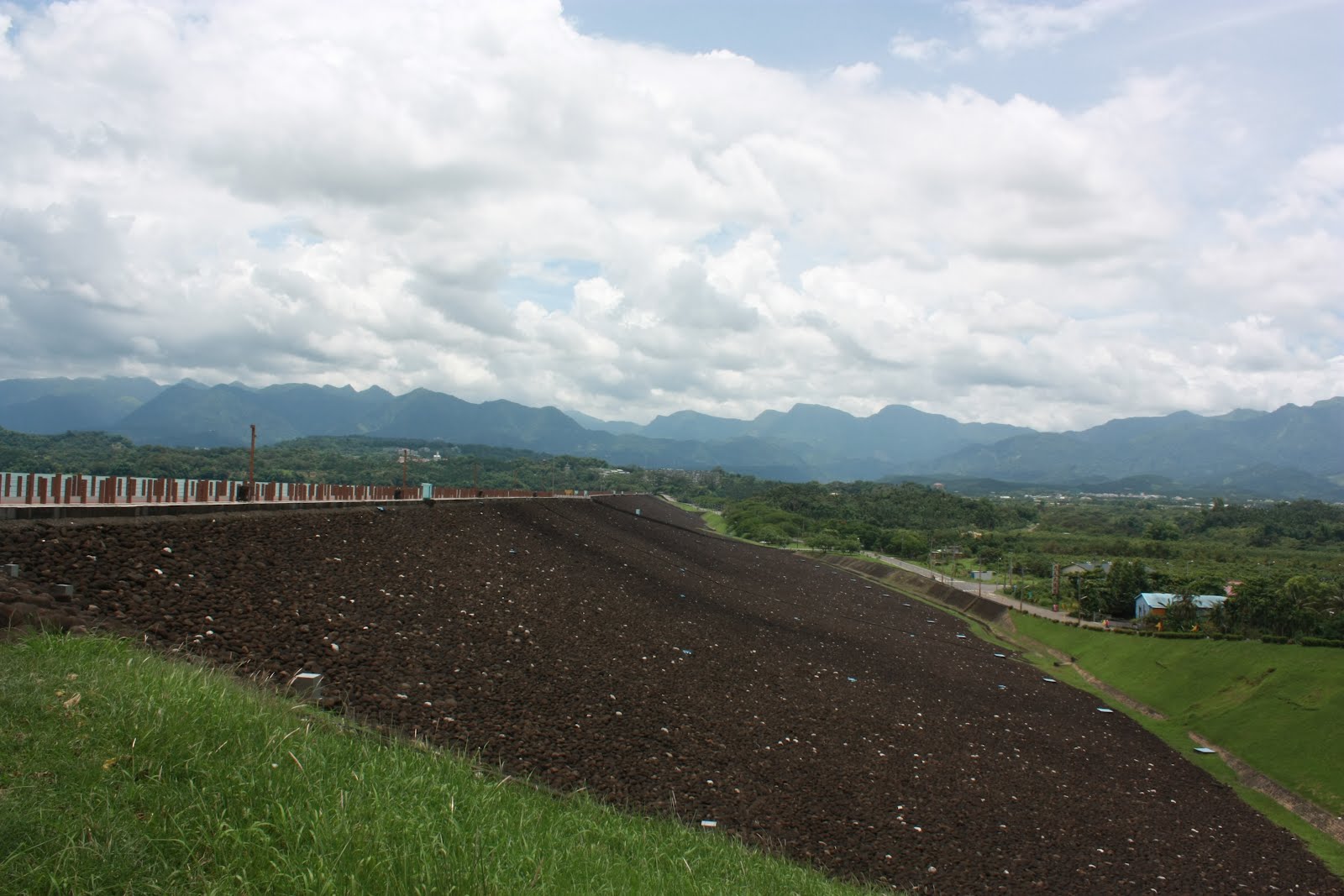
 With a crest length of over 1.5 kilometers in a straight line from east to west, the southern stretch of the Renyitan reservoir dam is the second longest in Taiwan (behind the dam at Agongdian reservoir, which is 2.3 kilometers long). At weekends and during public holidays, the dam is a curiously popular place for the locals to go walking. Unlike the dam at Agongdian reservoir in Kaohsiung however, which lies within walking distance of the little town of Gangshan and is part of a specially designed, ten-kilometer exercise trail, the dam at Renyitan reservoir must be approached by road and lies several kilometers away from the centre of Chiayi city. At 19 meters in height (28 meters above sea level), Renyitan's dam is also one of Taiwan's lowest though it does not need to be climbed at either end since the public road runs up to meet it. Compositionally, the dam is built around a clay core in the centre with, on the downstream side, a further impermeable layer buttressing the core, followed by a semi-permeable layer of rock-fill ("pervious material") and then the dressing on the outside. On the upstream side of the dam (the side against which the weight of the water rests), two further layers of semi-permeable rock-fill are separated from the central core by a drainage channel set in a sand-and-gravel membrane which presumably issues out into the resevoir itself (this point is not made clear by the diagram pictured above-right).
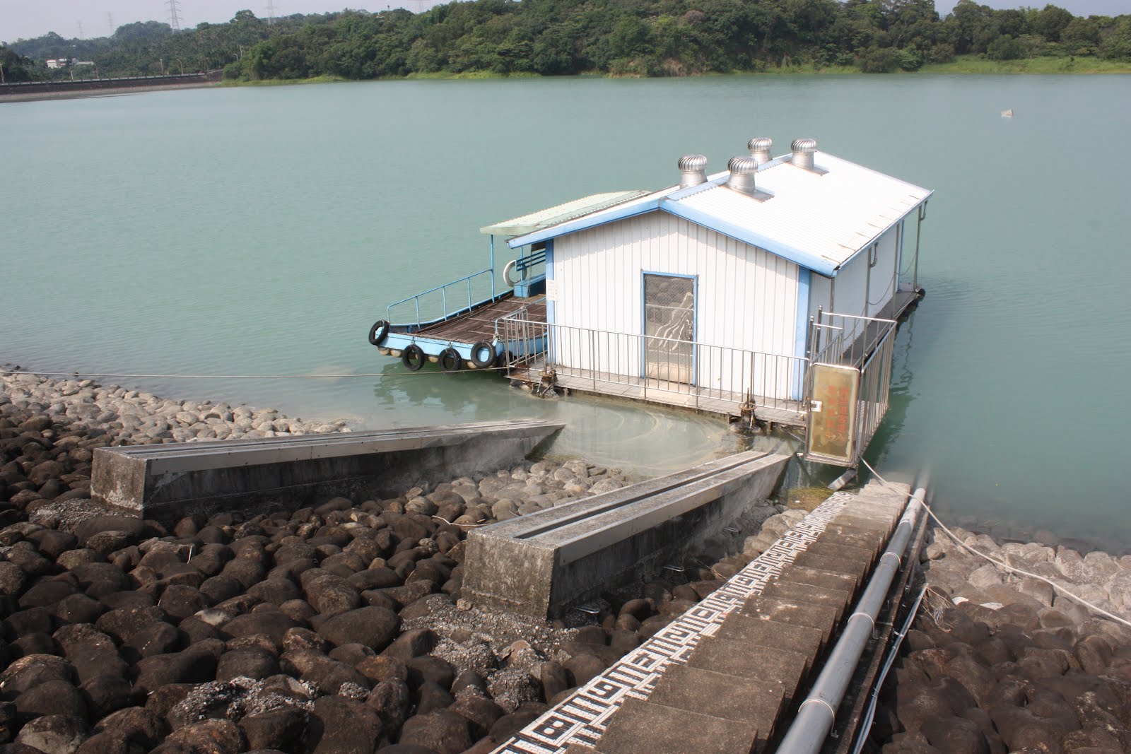 Although most noticeable to the south, the dam also encloses Renyitan reservoir to the west up to a certain point after which the natural high ground to the north takes over. A road runs along the crest of the dam northwards and upwards until it intersects with route 159 running east-west above the reservoir to the north. Beside a certain point along this western stretch of the dam, a monitoring station appears to float on the surface of the water with a little boat moored alongside it. Although a strange appearance on first sight (because it looks like a small house floating on the water), the station is actually fixed to a set of slide-rails set in concrete along the upstream face of the dam. Presumably, the station is to be dragged out of the water and somehow fixed to the side of the dam during an extreme flooding event that would threaten to overwhelm it. Two cables are attached to the base of the station and are stretched out along the upstream face of the dam and tied around iron rings set in concrete blocks. The obvious way this arrangement would work would be for the two cables to be attached to hydraulic winches mounted on a suitably stabilized heavy vehicle; as the winches pulled in the cables, the station would be dragged out of the water and up along the rails, much like the fishermen-farmers, commonly found across Taiwan's fresh-water bodies, use hemp-rope to drag their pipe-rafts onto the shore at an angle.

 Unusually, the spillway at Renyitan reservoir is not a prominent architectural feature as at other reservoirs. Set back within a small recess in the dam to the south-west, the spillway gate is unlikely to draw anyone's attention because it actually sits beneath the road which runs north-westwards across the crest of the dam. A small, blue hydraulic gate perhaps three and a half meters across by a meter in height, the gate is set atop a short, concrete baffling step and only becomes visually obvious when viewed from the high ground to the north of the reservoir. When fully opened, the gate leaves a two meter high aperture for the water to pass through; to open up, the gate is lowered backwards toward the spillway, moving through an arc of perhaps ninety-five degrees until it sits flush within a groove in the concrete surface of the spillway so as to reduce the turbulence of the water flowing out into the steep and narrow spillway on the other side. Set an angle of approximately forty-five degrees, the spillway chute allows the excess water to cascade downwards by almost ten meters before levelling out again and being met at a diagonal by water from a nearby drainage channel. Although this flat area of the chute may sometimes contain a small pool of stagnant water, during operation in periods of heavy rainfall, the water will thunder down further below as the chute hurtles on its way down to the Bahzang river almost a kilometer away to the south. A small access road runs down parallel to the spillway through the small farms set alongside its course.
 Renyitan Reservoir Tourist Facilities

 In the south-west corner of the reservoir overlooking the main, southern stretch of the dam out to the east, there is a small area set aside for public recreation. Aside from a car park and public toilets, there is a terraced pavillion attractively lined with palm trees. Here visitors can sit in the shade to eat and drink whilst looking out over the reservoir eastwards toward the mountains. The road bends around this terrace to the south where it proceeds to run downhill and stretch out in parallel to the dam. However, just as the road begins its descent, there is small area adjacent to it where food and drinks vendors camp out beneath two corrugated metal rooftops. The food is typical of nightmarkets; hot-dogs, stinky tofu, fish-balls, "pig-blood cake" (one of my favourites which is also commonly known in England as "black pudding") and so on. Two or three of the vendors also have large refrigerators where they stock water, juices, soft drinks, teas, but also beers (either Heineken or Taiwan Beer - the locals' choice) and even Paolyta which is a kind of "medicinal" alcoholic beverage containing both a moderate amount of alcohol and caffeine; it has a sweet, liquorice-like flavour owing to the use of what I've always presumed is the herb angelica sinensis which is also used to flavour certain types of traditional soups. On my several visits to Renyitan reservoir I always bought bottles of chilled water here but on my last visit the old woman asked me if I wanted to buy beer (at sometime after 11am in the morning!). And actually, when the weather is especially hot and humid, the shaded pavillion in this little corner of the reservoir is not a bad place to sit down, have a drink and enjoy the view - especially on a reasonably clear day with the clouds rolling over the mountains...
***

No comments:
Post a Comment
Comment moderation is now in place, as of April 2012. Rules:
1) Be aware that your right to say what you want is circumscribed by my right of ownership here.
2) Make your comments relevant to the post to which they are attached.
3) Be careful what you presume: always be prepared to evince your point with logic and/or facts.
4) Do not transgress Blogger's rules regarding content, i.e. do not express hatred for other people on account of their ethnicity, age, gender, sexual orientation or nationality.
5) Remember that only the best are prepared to concede, and only the worst are prepared to smear.