A change of plan, as suggested by my girlfriend, went into action yesterday as instead of taking the expensive and weather-doomed trip up to Keelung, I drove south through the sweltering heat to Pingtung city and reacquainted myself with long forgotten roads and streets I hadn't used since my earliest years in Taiwan. I left the house in Tainan city at 8 a.m. after walking the dogs and reached the Dongnang river weir and intake at just before 10.30 a.m., which was somewhat longer than I expected. What I had in mind was to photograph the weir, intake and the pipeline and hopefully get some questions answered; after that I had hoped to visit both Fongshan reservoir itself and the Kaoping weir in Dashu provided enough time and energy remained to me...
 |
| Looking northward to a fork in the Dongnang river as it flows past me down to the weir and intake for the Fongshan rerservoir pipeline. It was a brilliant, blue morning despite a forecast for heavy rain. |
 |
| The eight-gated weir with the intake structure on the western shore alongside provincial highway 27. |
 |
| Four hydraulic gates to let water through the check-pit into the pumping house wherein it will be pressurized for the pipeline to Fongshan reservoir. |
 |
| The intake entrapment pen which uses four hydraulic gates surmounted by that blue, corrugated iron roof. |
 |
| The four gates for the intake entrapment pen, each with a filtering grate to keep out driftwood and other debris. |
 |
| Inside the pumping house, where water is pressurized before entering the pipeline for Fongshan reservoir. The manager showed me around the site and was happy to answer questions about the Dongnang river, the pipeline and even Fongshan reservoir itself. I was delighted. One of the questions I asked was about the quality of the water which his pipeline delivers to Fongshan reservoir, given that there had been problems with pig waste and other farm effluent in the past. He said that the pollution had been reduced, but not by means of expensive filtration, but simply by providing better drainage channels for the farms to prevent the effluent entering the Dongnang river. He also provided a number of interesting answers to several other questions which had previously puzzled me. |
 |
| After being received so well at the Dongnang river intake, I drove back north stopping at convenience stores in search of a toilet, and though I stopped at four different stores, none of them had a toilet. Eventually I found one by the side of a village road well off the main highway which was adjacent to a fish pond full of carp and several turtles. After taking care of business, I paused for a few minutes to drink and take shots of the turtles in the various poses I found them lazing around in... |
 |
| Turtles are not really my kind of animal so I don't know what species this is. |
 |
| This idiot had somehow lodged himself upside down in this urn. I couldn't reach far enough to fish him out. |
 |
| I don't think he could get out by himself, though I don't know enough about turtles to be sure. |
 |
| Comical as it was, in hindsight I think I should have climbed in to fish him out. |
 |
| The pipeline on the south side of the Kaoping river flood plain, which runs north-east to south-west, parallel to that row of cumulus clouds floating above it. The low, sloping hill in the distance lies just to the south of Fongshan reservoir, the destination of this pipeline. The distance from the Dongnang river intake to this point is just over three kilometers, and the span across the Kaoping river itself is almost two kilometers long. |
 |
| This milestone sasys "Xinyuan Embankment", "Xinyuan" being the name of the second township directly south of Pingtung city, after Wandan township. |
 |
| No entry, obviously. |
 |
| Telephoto shot along the left side of the pipeline; the tower in the background to the right lies on the northern shoreline of Fongshan reservoir, so the reservoir is literally on the other side of those trees. |
 |
| Looking northwest to the petrochemical processing complex of Kaohsiung's Linyuan district (林園). |
 |
| A grey heron climbs up through the air with the coal dry dome of Formosa Plastics Corporation in the background. |
 |
| First of a series of shots of the various buildings at the Formosa Plastics Corporation plant. |
 |
| Second of such. |
 |
| Third. |
 |
| Fourth. |
 |
| Fifth. |
 |
| Sixth. |
 |
| Seventh. |
 |
| Eighth. |
 |
| View northwest toward Linyuan from the reconstructed highway 17 bridge. I remember when this bridge was destroyed by Typhoon Morakot in 2009; I had previously used it many times to drive south to Kenting. In those days it was a narrow, two lane dual carriageway, without a dedicated motorcycle lane, let alone a bicycle path. The new bridge is a vast improvement on the old one. |
 |
| The pipeline stretching away southward toward Pingtung's Xinyuan district from the northern shoreline of the Kaoping river basin. |
 |
| The message is to avoid wasting water. |
 |
| I don't know what this abandoned building used to be, but I'm guessing it may have been a kind of well to draw water out from the Kaoping river and into an underground pipe, long since disused due to erosion. |
 |
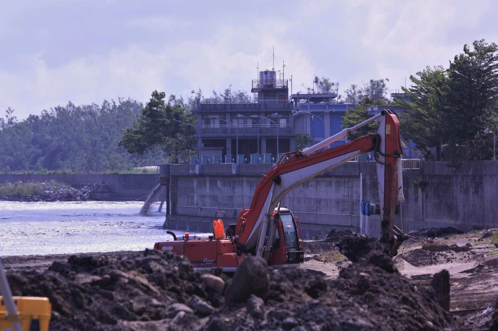
| Ongoing construction just north of the Kaoping weir (see below). The Southern Taiwan Water Bureau is preparing the ground here for a flood prevention wall to stop the farms from being flooded during heavy rainfall events when the river surges and bursts its' banks. |
 |
| The essential problem with the Kaoping river is that half of its' basin is just a sea of mud. That's why water is supplied to Fongshan reservoir from the much smaller and comparatively cleaner Dongnang river further south in Pingtung. The water from the Kaoping has to be filtered and chemically treated before it can be pumped to Cheng Ching Lake (a small amount is also pumped to Fongshan reservoir, entering beneath the northwest shoreline - just east of the northern dam where it takes the appearance of gas bubbling up from beneath the surface). |
 |
| The Kaoping river weir intake building with (blue) pumping house in the background; note the two spillover sluicepipes returning filthy water back to the river. |
 |
| Public noticeboard regarding the construction project for the new flood drainage channels and the flood protection wall. |
 |
| Close up on the diagram; the red line is the planned flood drainage channel, whilst the blue line is the planned new flood protection wall. |
 |
| The old Dashu railway built by the Japanese which once spanned the Kaoping river (then somewhat amusingly called the "southern Tamsui river" apparently.). The bridge is long since disused and has been partially destroyed by typhoons several times, with it being reconstructed for tourism purposes. |
 |
| Taiwanese tourists on the old railway bridge. |
 |
| Parting shot of the bridge, with its' modern replacement to the left. |
I will take another two trips this week, starting tomorrow morning, when I will go back down to Kaohsiung to do a few things I wasn't able to do at the weekend, and then this coming weekend I'll be back up in Taipei for a tour of Feitsui reservoir; I can't wait, but when Sunday comes around I'm going to be exhausted.


No comments:
Post a Comment
Comment moderation is now in place, as of April 2012. Rules:
1) Be aware that your right to say what you want is circumscribed by my right of ownership here.
2) Make your comments relevant to the post to which they are attached.
3) Be careful what you presume: always be prepared to evince your point with logic and/or facts.
4) Do not transgress Blogger's rules regarding content, i.e. do not express hatred for other people on account of their ethnicity, age, gender, sexual orientation or nationality.
5) Remember that only the best are prepared to concede, and only the worst are prepared to smear.