There are few motorcycle journeys out of Tainan as long, arduous and nerve-wracking as the day trip south from Tainan to Kenting and back again, and I should know, because I have done most of the others. What makes it difficult, particularly in the summer months as now, is not its' length per se (something like 150 kilometers), or the fact that you must negotiate traffic through three different cities, but that the road is typically crowded with holiday-makers all driving down to Kenting, many of whom are... there is no other way to put this... bad drivers. It was with this prospect in mind that I awoke at 4am yesterday morning still feeling the effects of a back strain I had inccurred the day before whilst deadlifting in my garage (I probably had my shoulders slightly too far forward and over the bar). The intention was to drive all the way down south to the Hengchung peninsula to photograph a small reservoir I had hitherto neglected, and then maybe take a quick swimming break in nearby Kenting. But at 4am and with a bad back I struggled to rouse myself, though I eventually dragged myself out of my coffin; once the dogs had been out for a walk and I had filled up with coffee and breakfast and taken a shower the drive to Hengchung and back suddenly began to seem manageable. I left the house at 6.15am, over an hour later than I had originally intended.
These days, instead of driving down to Kaohsiung city via provincial highway 1, as I used to, I pass through the HSR station in Gueiren and make my way through the farms and industrial estates of Alian district before coming out at Agongdian reservoir (and from there it is the 186 south and then a quick switch over to Chengguan road which follows underneath freeway 10, before turning south onto the 183 which takes me through Fongshan and Daliao and thus across the river to Pingtung). This time an obvious benefit of taking this alternative route through the farms was that I would be able to photograph Agongdian reservoir - which is worthwhile doing now, because every summer it is drained in order to allow for the removal of sediments. Here is the view from Xiaogangshan at about 7am in the morning - the drainage is probably complete even though the reservoir is still covered in standing, shallow water reflecting the sun...
 |
| Agongdian reservoir early in the morning; note the excavated "path" in the middle of the reservoir. |
 |
| From Xiaogangshan looking south-south-west to Kaohsiung city across the High Speed Rail line. |
I left Xiaogangshan after a couple of minutes and then parked outside the reservoir premises to use the bathroom and then walk through the park to photograph the reservoir from the south east looking north west with the sun behind me.
 |
| Xiaogangshan to the left and Dagangshan to the right and the reservoir in between; Agongdian reservoir was designed to be shallow, but the inflow of sediments from the Wanlai stream and the curiously named "Zuoshui" stream have ruined it and it now needs to be drained every summer. |
 |
| The water intake tower in the distance with Xiaoganshan behind it. |
 |
| A close up on the water intake tower - note the stain of the usual high-water mark. The X-shaped structure to the left is the water gate for the irrigation outlet. |
 |
| A close up on the excavator sitting idle across from the tower; note the presence of egrets in the water - they will be standing rather than floating, which is an indication of how shallow the water is. |
 |
| Layers of sediments around which the water flows. This mud is carried by the river from the nearby Wushanding "muddy volcano". |
 |
| The Wanlai stream at the back end of the reservoir, almost dried up. |
 |
| The two stream beds converge to enter Agongdian reservoir beneath the southern footbridge. One of at least two mysteries I haven't yet solved about Agongdian reservoir, is how exactly the two feeder streams dry up during the wet summer months. I have two conjectures about this; either the drainage rate of the reservoir is such that the stream beds never fill up except during rainfall periods, or there are additional water drainage channels further upstream which I have not yet discovered. I favour the first conjecture, but there is sufficient doubt in my mind due to my previous failure to locate the spillover channel from the Yanchao control gates that I can't be sure. At any rate, I think I can probably get an answer to this one way or another. |
 |
| The now dried up Wanlai stream winding its way down from the hills. |
I returned to the parking lot at about 7.30am and shortly stopped again in Yanchao to buy some sunblock with which to smother my nose, face and exposed extremities, and then proceeded down the 186 to Kaohsiung and eventually out over the Kaoping river and into Pingtung county. Whilst crossing the Lumang river (率芒溪 - not sure about the correct translation), I noticed a small herd of cows crossing the river...
 |
| Cows crossing the river, or at least wading into it in order to cool off. |
The journey southward, though tiring, was not especially eventful and was filled with the usual mixture of wonder at the mountains and coastline and the stresses of anticipating the movements of the surrounding traffic as I passed through it. People in cars using the hard shoulder to overtake is not an uncommon site on highway 26, along with all manner of other, even more reckless idiocies. When I eventually reached Hengchung it was well after 9.30am and the sun was now high up in the sky. I found Longluan lake without much difficulty, simply by taking the right-hand turn off the 26 toward the nuclear power station - after a short distance that road brings you alongside a viewing area over the lake from the south...
 |
| The red sign in front of the lake indicates that it is a protected area under the jurisdiction of Kenting National Park, which is something I hadn't known. |
 |
| Another signboard, giving limited information about the lake; apparently it was a natural lake formed by rainwater collecting in a flat basin and was later engineered into a local irrigation reservoir in 1984. |
 |
| A large field prefaces the lake to the south; can you spot the cattle in the distance? |
 |
| Myself standing at the south end of Longluan lake reservoir. |
Heading back onto the road around to the north end of the lake, I stopped at the half-way point to enter the premises of an ecological education center. I found it to be a badly designed and frustrating place. I knew that it's function would be to educate the public about the lake and the wildlife, particularly ducks and other birds that live there, but my purpose in entering was to get down to the western shoreline of the lake for more photography. I found the place to be frustrating right from the start. First, in order to enter the premises drivers must pay for a parking ticket from a machine. That should not be a problem, but it was. The parking fee was only NT$20, but the machine accepted neither coins or notes. It was simply expected that visitors would have some sort of membership or other smart card (and not a credit card). Naturally I did not have said card (unless it was an Easycard). Another problem was that the signs were in Chinese only. However, I could read the bits about fees and fortunately, because I was on a motorbike there was just enough space for me to simply squeeze around the barrier. Then the parking spaces - most of them were "reserved for green vehicles". So this was clearly a site that had been designed for religious zealots by religious zealots. There was not even a definition of "green vehicle" provided. Would my small engined (150cc) motorbike count as "green" given that it emits far fewer pollutants than any car? Or would I have had to paint the fucker green?
 |
| Warning: you are now entering an eco-fundie zone. |
It was extremely hot and thankfully there was a bathroom near the carpark which was not (thank god) one of those composting toilets, but like all Taiwanese bathrooms there was no toilet paper (it's an environmental hazard, obviously). There was also a big, fat black labrador sitting in the shade at the entrance to the men's bathroom. He had lost one of his front paws (presumably to an encounter with a Taiwanese driver), so he got half my pack of beef jerky. The actual ecological education center was located a good ten minute walk away from the car park. Yet rather than build a single path between them, they had built several, leading me to think that at least one of them might lead down to the lakeside where I could take pictures. Instead they all wound around back onto one another. There were also "paths" leading away that had been cut into the bush, but which were not prefaced with signs as to their function. Following one of these in the hope of finding my way down to the lakeshore, I instead found that it was simply an access route to the base of an electricity pylon. That this and other similar paths had not been signposted was just stupid. That was the last straw for me - I lost patience with the place and immediately headed back to my motorbike to get water to drink and head over to the north side of the lake where the irrigation gates stood...
 |
| The irrigation canal headed by Longluan Lake's dam and four irrigation gates. |
 |
| A close-up of the dam and irrigation gates, only one of which was open. Note the reactor buildings and pylons from the nuclear power station in the background. And can you spot the old man moving about in the water? |
 |
| Here he is: this is completely normal behaviour among Taiwan's rural population and so I didn't worry about him. |
 |
| The usual warnings about deep water and so forth (edit: and numbers of deaths, though the actual numbers are absent), though this is a non-standard sign and may not have been erected by the Water Corporation. |
 |
| Overlooking the lake from the north-west corner on top of the dam. |
 |
| Looking south-west toward the western shoreline and what must be the ecology center building, which has three token wind-turbines standing guard over it. |
 |
| The two reactor buildings for the Kenting nuclear power station in the distance. Disregarding the cancelled plant at Gongliao in northern Taiwan, this is the most recent of Taiwan's three nuclear power stations. |
 |
| Pylons and electricity cables leading away from the power station to join the national power grid. They pass over the flat rooftops of Water Corporation buildings. |
 |
| They pass over the town of Hengchung also and away up the hillsides... |
I had only spent an hour at Longluan lake, but the heat was already killing me. I needed fresh water to drink and a place to sit down and just stare at the wildlife and maybe go for a quiet swim and float around on my back for a short while. So naturally I completely ignored Kenting - there are too many people at the south bay and at the other beaches. I stopped at the 7-11 opposite Fraggle Rock (Chuanfanshih) to get some drinks and then parked outside the little B&B place I had stayed at many years ago now with my then-girlfriend. I have fond memories of Fraggle Rock and snorkelling around chasing fish and laughing at the locals with their lifejackets and safety equipment holding hands with each other because they cannot swim...
 |
| I picked my way through the sharp rocks and sat down for a drink, but swimming was out of the question as it as high-tide. |
 |
| Looking back westward toward Kenting (on the other side of that hill). This is pretty much the southern end of Taiwan. |
Not finding adequate swimming conditions at Fraggle Rock, I decided to head up to one of the beaches on the east coast just past Erluanbi. The views over Taiwan's southern Pacific coast from just after the observatory are always spectacular...
 |
| Overlooking the Pacific Ocean; I used to stare in wonder at this on the map on my bedroom wall when I was a child. I never thought I'd actually swim in it one day - and I've swam in it many, many times now. |
 |
| Looking back down south along the coast with the observatory just visible in the background. |
 |
| I left my kit with a family under a beach umbrella and spent half an hour out in the ocean on my own. Looking back at the breakers I had wrestled with earlier - once you get past these it is smooth and calm and you can lie on your back looking at the sky. |
After my quick swim (I would have stayed longer, but I was conscious of the demands of driving all the way back up to Tainan city again), I sat down to chat with the mother of the family after the kids and their father had gone off to play. She asked me the usual questions that Taiwanese ask foreigners and we talked about houses for a bit - apparently house prices in her area of Taichung city are considerably higher than down in Tainan. After that, I went back up to the bike and got ready for the return trip north to Tainan.
Going back is more difficult. Partly it's because I was leaving at the hottest time of the day, just after 1pm and also because what you have to look forward to is no longer the beaches and sea air of the Hengchung peninsula but the insane traffic of highway 26 (later changing to highway 1) and the task of negotiating yourself through the next three cities. On my way back northward up the 26, sometime before Fangshan I think, I drove past an accident scene - a young man lay dying (if not already dead) on the other side of the road - his scooter lying prone on the tarmac and blood streaming from out of his head. A crowd of people stood around him trying to do CPR and pouring water onto his head wounds. If I had been a medic I would have stopped to do whatever I could, but I am not and there was nothing I could do. I drove on, thinking about that for the rest of the trip. About 10 minutes later I saw the ambulance racing southwards for him. Almost certainly too late. What would be front-page news in England is an everyday occurance in Taiwan. I just concentrate on making sure that that particular nightmare - lying on a road somewhere miles from my dogs, blood pouring out of my head - never catches up to me. I am not sure how I would like to leave this world, but I am certain that is
not how I want to go.
I made good time, as safely as could be reasonably asked, and through downpours of rain in Pingtung city. Soon I was heading back up Chengguang road from Kaohsiung's Renwu district to Tainan city. When I made it back to Agongdian reservoir I took some repeat pictures from Xiaogangshan...
 |
| Agongdian reservoir at about 4pm; the mudflats clearly visible with the sun having swung around to the west. |
 |
| A similar shot taken with my HTC phone, which is slightly better I think. |
 |
| The channel dug by the excavator to allow the water from the feeder streams to make its way toward the dam gates. |
 |
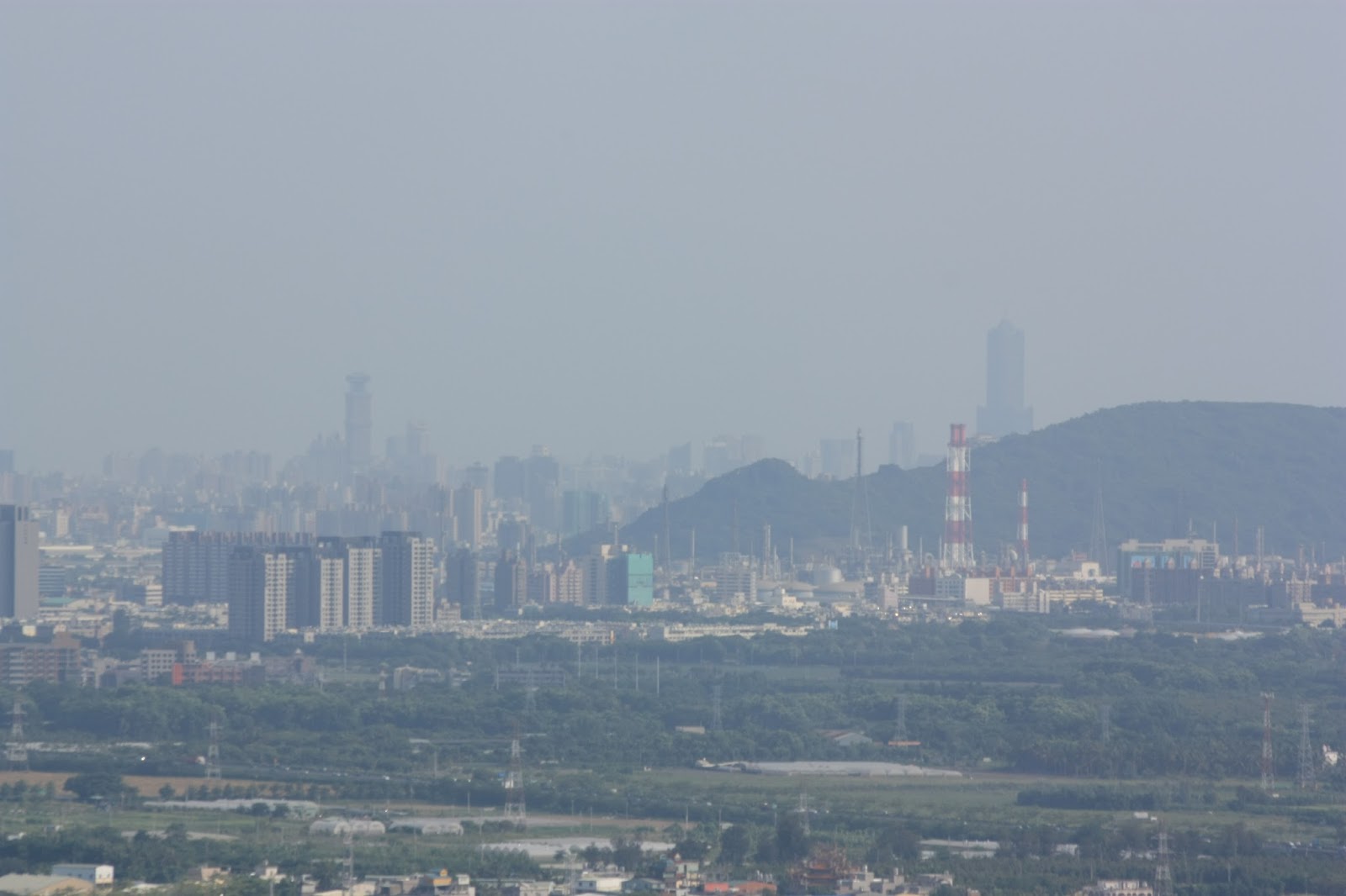
| Another long-lens shot looking back toward Kaohsiung city with the industrial area of Nanzih in the foreground and 85 and 50 buildings in the background. |
 |
| E-Da Medical University, which I had driven past on the 186 only twenty five minutes or so earlier. |
After a long drive, I finally got home in one piece, if absolutely shattered. I took a shower, got changed, grabbed a beer from the fridge and took all the dogs out to the park at the back of my house...


No comments:
Post a Comment
Comment moderation is now in place, as of April 2012. Rules:
1) Be aware that your right to say what you want is circumscribed by my right of ownership here.
2) Make your comments relevant to the post to which they are attached.
3) Be careful what you presume: always be prepared to evince your point with logic and/or facts.
4) Do not transgress Blogger's rules regarding content, i.e. do not express hatred for other people on account of their ethnicity, age, gender, sexual orientation or nationality.
5) Remember that only the best are prepared to concede, and only the worst are prepared to smear.