
 Stretching out amongst the low-lying hills midway between the mountainous eastern region of Tainan County and the sweeping agricultural plains to the west, Wushantou reservoir occupies a unique place in the economic and geographic history of Taiwan. It was the first large scale reservoir to be completed in Taiwan since the advent of the industrial revolution*. Built between 1920 and 1930, Wushantou reservoir was a first attempt in several respects; it was a first attempt for its chief engineer, then 33 year old Yoichi Hatta working at the direction of the colonial Japanese government;
  it was a first attempt at a large scale irrigation reservoir in Taiwan using modern construction methods; it was also the first reservoir of its kind and on this scale in south-east Asia. Wushantou reservoir stretches itself out over an area of approximately 13 square kilometers (just over 8 square miles) in a shape vaguely resembling a letter "W" - both fact and impression can only be visually appreciated from the air. Its size in terms of surface area alone means that, although it is not especially deep (the dam has a crest elevation of just over 66 meters [216 feet], but the average depth is probably closer to 30 meters [98 feet]), it remains even to this day one of Taiwan's larger reservoirs; with a storage capacity of 154 million cubic meters (505 million cubic feet), it is Taiwan's sixth-largest reservoir by volume and the second largest by surface area. Because it was the first of its kind, it is perhaps no exaggeration to suppose that no other reservoir has been as consequential to the historical development of agriculture in Taiwan than Wushantou reservoir.
Wushantou Reservoir Dam & Spillway

 For all its historical significance however, Wushantou reservoir attracts relatively few visitors; although there are some tourist facilities on the premises (including a water play-park for children, a souvenir shop and a small museum), the dam itself remains an aloof and windswept place. The views looking out eastwards from the dam itself are generally poor, since the full eastward expanse of the reservoir is obscured from the eye by the stubborn interjections of topography; chains of low-lying hills form fractured peninsulas
  and isolated islands that, accentuated with dense canopies of vegetation, break up the visitor's gaze, leaving unchallenged only the pool of water immediately below the dam. Unlike other reservoirs, Wushantou does not offer up picture-postcard shots to the casual visitor; what visual rewards there are for the photographer are to be gained from the north-south curvature of the dam itself, the spillway to the south end and, for the genuinely curious, there are fantastic views to be had from the little village of Wangyegong to the east
  looking out westwards toward the dam. It must be said however, that good though the views from Wangyegong may be, they are to be had from the balconies of people's homes for which I had to ask permission. Wangyegong is a sleepy little village astride steep, rough and narrow little farmers' roads unsuitable for anything other than the little blue trucks and farmers' bikes they use out there. Like other little villages neighbouring route 174 around Wushantou reservoir and off south into Nanxi district, a lot of the people in Wangyegong are farmers growing mostly citrus fruits: oranges and limes.
 Wushantou reservoir itself rests against an earth-embankment dam over 1.2 kilometers long from north to south. The dam has a crest elevation of over 66 meters except at its' southern end, where it is perhaps closer to the 60 meter mark; this is to allow for a spillway to drain off flood waters and thereby protect the integrity of the dam from the build-up of excess pressure. The spillway is unusually large and striking. It is 239 meters wide and perhaps twice as deep (it can be clearly seen from the side of route 174 out to the west), but the
  crest of its recursively partitioned straining arch can be little more than 2.5 meters in height. This prorated arch was so designed as to dissipate the excess energy of flood waters and thereby ameliorate the effects of erosion upon the downward slope of the spillway itself over time. The dimensions of the spillway are large enough to allow flood waters to exit the reservoir at a rate of 1,500 cubic meters per second and flush out into a channel running south-west below.
 Beneath the centre-point of the dam, a series of concrete, copper-encased hydraulic pipes allow the outward passage of water at 144 cubic meters per second into a recepticle channel which then carries the water to a control station from which it issues out both northwards and southwards into the irrigation trunk canals. Consisting of (from the inside out) local clay, sand, gravel, sandstone rock and concrete, the dam was constructed by "semi-hydraulic fill"; this means that the materials for the core and outer shell of the dam had to be deposited at the embankment-location and then "washed" into place using pressurized water jets. At the time this construction method was relatively new (though it has long since been rendered obsolete by cheaper and technologically superior methods). It was also quite risky because its success would depend entirely upon the relative permeability of the clay to be used in the core - were the clay too corse, then the core could not be properly drained after being "washed" into position which would result in a weak and unreliable structure. Fortunately, the local clay extracted from the district of Danei (大內區) to the immediate south of Guantian (官田區), was of a fine enough quality to instill confidence in the engineers that it could be sufficiently drained and dried out prior to the construction of its outer shell. Although the clay for the dam's core was locally sourced, the other building materials for the dam had to be fetched from further afield and this necessitated the laying of several branch railroad lines which would subsequently be dismantled one by one as the entire project neared completion.
Wushantou Reservoir's Agricultural Importance

 Unlike most modern reservoirs, Wushantou was originally designed with a single purpose: the irrigation of the alluvial "Chia-nan" plain (嘉南平原)** which spans much of the south-west of Taiwan. When Wushantou reservoir was originally built in the 1920s, one of the primary objectives of the colonial Japanese government was the development of agricultural products for export to Japan. Under Japanese rule, sugar cane and rice were the primary cash crops grown throughout the Chia-nan plain; and indeed they remained so until well after the end of the Second World War and the replacement of Japanese rule on Taiwan with R.O.C rule. Today however, sugar cane is grown more profitably elsewhere but the rice remains. The predominant culinary preference for rice among the Taiwanese can be perplexing; although rice is generally more nutritious than the far less water-demanding and far more economical potato plant, for many Taiwanese people, rice-based dishes often form not only lunch, but breakfast and dinner as well - and sometimes every day of the week. Were it not for this seemingly unshakeable preference for rice (and not only rice, but specifically Taiwanese rice), perhaps the same number of people could be fed from a fraction of the current use of water and land.
 The irrigation of the Chia-nan plain, which covers some 1,500 square kilometers (579 square miles), is achieved by means of two primary irrigation canals issuing forth from the reservoir, one running northwards and the other southwards. Subsidiaries of these two canals branch out westwards at several points to supplement the seven natural rivers penetrating the plain. The borrowed map to the right gives some indication of the immense scale of this irrigation work; the southbound trunk canal reaches as far south as
  the Yanshui river (鹽水溪) some 14 kilometers (9 miles) away, whilst the northbound trunk canal alone reaches all the way up through the remaining districts of Tainan county and through into Chiayi city to terminate in the Bazhang river (八掌溪) approximately 115 kilometers (72 miles) to the north of Wushantou reservoir.*** To add to that, the westward branch canals themselves and the numerous inlet and waste-water drainage ditches also account for substantial distances****. Prior to the construction of Wushantou reservoir and its accompanying irrigation canals, the area of the Chia-nan plain taken up by paddy fields was perhaps less than 5000 hectares, and yet afterwards, this area would be expanded almost thirty-fold. This would allow significantly increased agricultural production both
to feed the broader population, and to export to Japan. In keeping with the immense scale of the project,
the Yanshui river (鹽水溪) some 14 kilometers (9 miles) away, whilst the northbound trunk canal alone reaches all the way up through the remaining districts of Tainan county and through into Chiayi city to terminate in the Bazhang river (八掌溪) approximately 115 kilometers (72 miles) to the north of Wushantou reservoir.*** To add to that, the westward branch canals themselves and the numerous inlet and waste-water drainage ditches also account for substantial distances****. Prior to the construction of Wushantou reservoir and its accompanying irrigation canals, the area of the Chia-nan plain taken up by paddy fields was perhaps less than 5000 hectares, and yet afterwards, this area would be expanded almost thirty-fold. This would allow significantly increased agricultural production both
to feed the broader population, and to export to Japan. In keeping with the immense scale of the project,  there was also an appropriately immense financial cost: the final construction contest for the entire project was apparently over 50 million yen, which is likely to have been a sizeable chunk of the government's annual tax revenue and so, in the absence of the global financial markets that exist today, funding for the project was divided between the central government and the farmers, landowners and tenents - the people who would immediately benefit from the reservoir and the irrigation system.
Wushantou Reservoir's Background Geography

 Wushantou reservoir sits in a natural topographical concavity immediately below the western-most foothills of the central mountain range to the east. This geological depression is fed naturally by the snaking neck of the Guantian river (官田溪) in addition to numerous tributary streams from the surrounding foothills. However, since the tributary streams are relatively trivial in size and the Guantian river itself was insufficiently potent to satisfy the irrigation demands of the Chia-nan plain, the reservoir's water intake had to be augmented.
 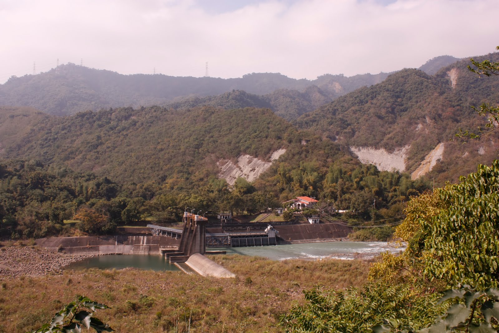 This was achieved by supplementing the Guantian river with a diversion channel receiving its' water from a minor dam across the larger Tseng-wen river further back to the east. Because the Guantian and Tseng-wen rivers are seperated by the so-called "Black Mountains" (烏山) from which Wushantou reservoir gets its name ("Wushantou literally means "Black Mountain Head"), this diversion channel had to stretch out for three kilometers beneath these mountains in order to reach the Guantian river. The construction of this channel began in 1922,
  was completed in 1929 and was undertaken concurrently with the construction of the Wushantou reservoir dam and the Chia-nan irrigation system. Although fifty workers were killed in a gas explosion toward the end of the first year of construction in 1922, the tunnel itself has not collapsed in the 83 years since its' completion, and has endured several large earthquakes. Approximately a mile and a a half (2.5 kilometers) from where it finally exits the Black Mountains, the diversion channel reaches an earthen dam
  under which its' water is funneled through a sink-hole to finally pour into the Guantian river heading off through the hills toward Wushantou reservoir. At the bottom of the dam there is a small, relatively recent hydroelectric power station which sells its output directly to the Taipower monopoly.
***
Although there are some facilities for local Taiwanese tourists at the weekend (a shop, a museum etc), the naturally fractal shape of the prehistoric basin in which Wushantou reservoir sits remains removed at several degrees of inconvenience from them.
Wushantou reservoir reserves its real rewards for the curious and resourceful.

*The Dutch East India Company had of course, during their prescence on Formosa between 1623 and 1661, overseen the construction of numerous irrigation channels across the Chia-nan plain. In addition to the archaeological evidence at Wushantou reservoir, it is claimed that the small Houtopi lake in nearby Xinhua district was also built by the Dutch and in Chiayi City, what is now Lantan reservoir (藍潭水庫) is apparently built on the remains of earlier efforts by the VOC.
**"Chia-nan" (嘉南) is a portmanteu of the first character-syllable of "Chiayi" (嘉) and the last character-syllable of "Tainan" (南): together they translate as something like "Auspicious South".
***Southward trunk terminus GE coordinates: 23,04,14.44 N and 120,19,1.60 E (a tributary to the Yenshui river). Northward trunk terminus GE coordinates: 23,35,42.93 N and 120,21,38.40 E (the Bazhang river running through Chiayi City).
****Together with the north and south trunk canals, the westward branch canals account for a total distance of 1,150 kilometers.
Great website to illustrate in English on modern recreation and engineering. Sam Shueh
ReplyDelete