Yet I began this trip without these specific problems in mind. Instead, my aim was to collect a few more shots of the northern dam at Wuchieh before retaking the 83 north alongside the river all the way up to Wan-Da; there I had no more clear objective than scouting around looking for interesting and unusual spots to photograph the reservoir and the dam.
As it happens, I was in for a few surprises...
 |
| Looking southward over the northern dam at Wuchieh; the pathway along the top of the dam is inaccessible to the public. |
 |
| The water intake for the original Japanese diversion tunnel; it was from here that Sun Moon Lake was fed water from the Zhuoshui river for over seventy years. |
 |
| I was surprised to learn that, contrary to what I had previously thought, there was an easily accessible spot from which the upstream face of the southern dam could be photographed in its' entirety; on the road bridge just before it tunnels through a mountainside. |
And then there was the big surprise. The area downstream from the reservoir which houses the hydroelectric station and its' switch yard is also a kind of park and just happened to be open whereas it had previously been closed. Presumably only Taipower employees and local aboriginals are allowed to drive vehicles inside because although I later saw a couple of motorcycles and a car inside the grounds, I was told to park my motorcycle elsewhere and make the trip through the park on foot. I signed myself in and handed over some ID in exchange for a visitor's pass. As I had woken up to the prospect of perhaps being able to see the downstream face of Wan-Da reservoir's dam, I strode through the park at what must have looked like a murderer's pace to close the distance between myself and the dam as quickly as I could and finish the job in a reasonable time.
The park is interspersed with various footpaths which double up as roads for vehicular access to the power station. Between these roads there are green spaces with various plants, flowers and trees maintained for their botanical interest (e.g. Formosan soybean). However the "you-are-here" site map for the park contained no visual reference to either the dam or the reservoir.
Not an encouraging sign.
The one path which led eastward beyond the power station and toward the dam had no signs of any kind. It begins by sloping gently uphill and rounds a bend beyond the power station. It became narrower and narrower the further I walked upward until eventually I came to a precipice where part of the cliff face had collapsed into the river a couple of hundred feet below. However, the path did not end there. Instead, it turned right, climbed up the side of the mountain and then ran further eastward along the edge of the precipice.
Because it runs so close to the edge of the precipice, it's not a walk to take if you are afraid of heights.
After a distance of less than a hundred yards, the path begins a steep and tricky descent (at this point it is covered with broken shale which just loves to slip and slide underfoot). The descent is shallow, perhaps thirty feet or so before striking off flat eastwards again into dense undergrowth. That undergrowth became denser the further I walked and I crossed two small streams before arriving at a stripped, terraced outcrop of soil being prepared for farming. I left the path and walked out northward across the soft terraced soil to the small farmhouse. The bloke who met me said there was no further road and that I would have to follow the riverbed itself if I wanted to get to the downstream face of the dam. I turned back and returned westward along the narrow path; I even tried following one of the small streams I had crossed hoping to find a way down to the river, but the reeds were so dense I would have needed a machete to get through them.
Disappointed, I returned to the narrow path and climbed back up the precipice and along to the western side pausing only to try to photograph an eagle who had ventured out to find food whilst there were no fireworks going off...
 |
| Crested serpent eagle: too distant to get a really good shot. |
The road along the reservoir's western bank is set quite high up above the shoreline. Yet not far north from the southernmost point there is an access road running downhill to the southwest corner of the reservoir. At the end of this road, there is a checkpoint beyond which are the water intakes for the hydroelectric power station. I switched my engine off and rolled down to a point about half a kilometer from the checkpoint. The guard dog still heard me and started barking, so I beckoned him to come and get some beef jerky while I took pictures.
 |
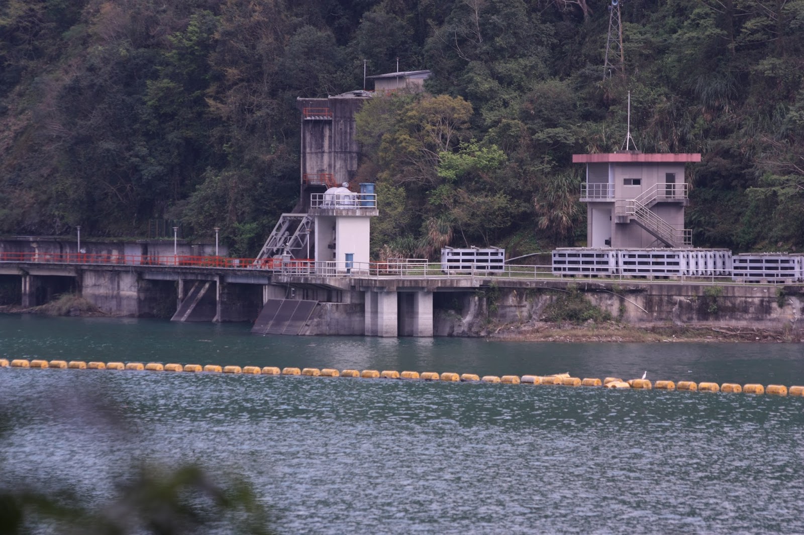
| Overlooking the water toward the dam gates in the south east corner of the reservoir. |
 |
| Close up on the hydraulic dam gates taken with the 300mm. Here's something I don't know: are these "standard" Tainter gates, or are they some other, alternative design as at Chiayi's Renyitan reservoir? The problem is that with the spillway on the downstream side being so steep, there may not be sufficient space for walls on which to mount trunnion pins for the radial arms that Tainter gates require. Until I can actually see the downstream face of the dam for myself I can't tell because there are precious few photographs of it available online. |
 |
| Water intakes for the hydroelectric power station downstream. |
 |
| These two tall structures are most likely sluiceway gates, which are probably so tall because their corresponding gates are at some tens of meters of depth below the surface. |
My next trip may not include any reservoir work at all. I want to return to Ershui, find a motorbike shop and order a rear rack for the black motorbike, as I have on the red motorbike. I am recurrently suffering from strains to my left latissimus dorsi and thoracolumbar fascia. I don't think these are caused by my exercise routine but by other things such as slinging that bag over one shoulder, sitting at low coffee tables and carrying one dog under my left arm while going to the park. A rear rack for the black motorbike, if it's big enough, will mean I won't have to carry anything while driving. And that will make forthcoming trips more comfortable.
No comments:
Post a Comment
Comment moderation is now in place, as of April 2012. Rules:
1) Be aware that your right to say what you want is circumscribed by my right of ownership here.
2) Make your comments relevant to the post to which they are attached.
3) Be careful what you presume: always be prepared to evince your point with logic and/or facts.
4) Do not transgress Blogger's rules regarding content, i.e. do not express hatred for other people on account of their ethnicity, age, gender, sexual orientation or nationality.
5) Remember that only the best are prepared to concede, and only the worst are prepared to smear.