Last Sunday morning (October 4th), I left the house at sometime after seven and picked up Ruby's sister Niki at about eight. I wanted to take pictures of the expanding reed swamp at Baihe reservoir, but I also wanted to return to the back of Tseng-wen reservoir to check on the construction progress north and south of Dapu
and I wanted to observe the new sluiceway construction at Nanhua reservoir. Usually, I would consider these to be three separate trips. To accomplish all of this in one day would require me to spend an unusually long time driving. Before we set off I estimated the distance to be somewhat over two hundred kilometers, and it turned out to be about two hundred and fifty kilometers, so I wasn't far wrong.
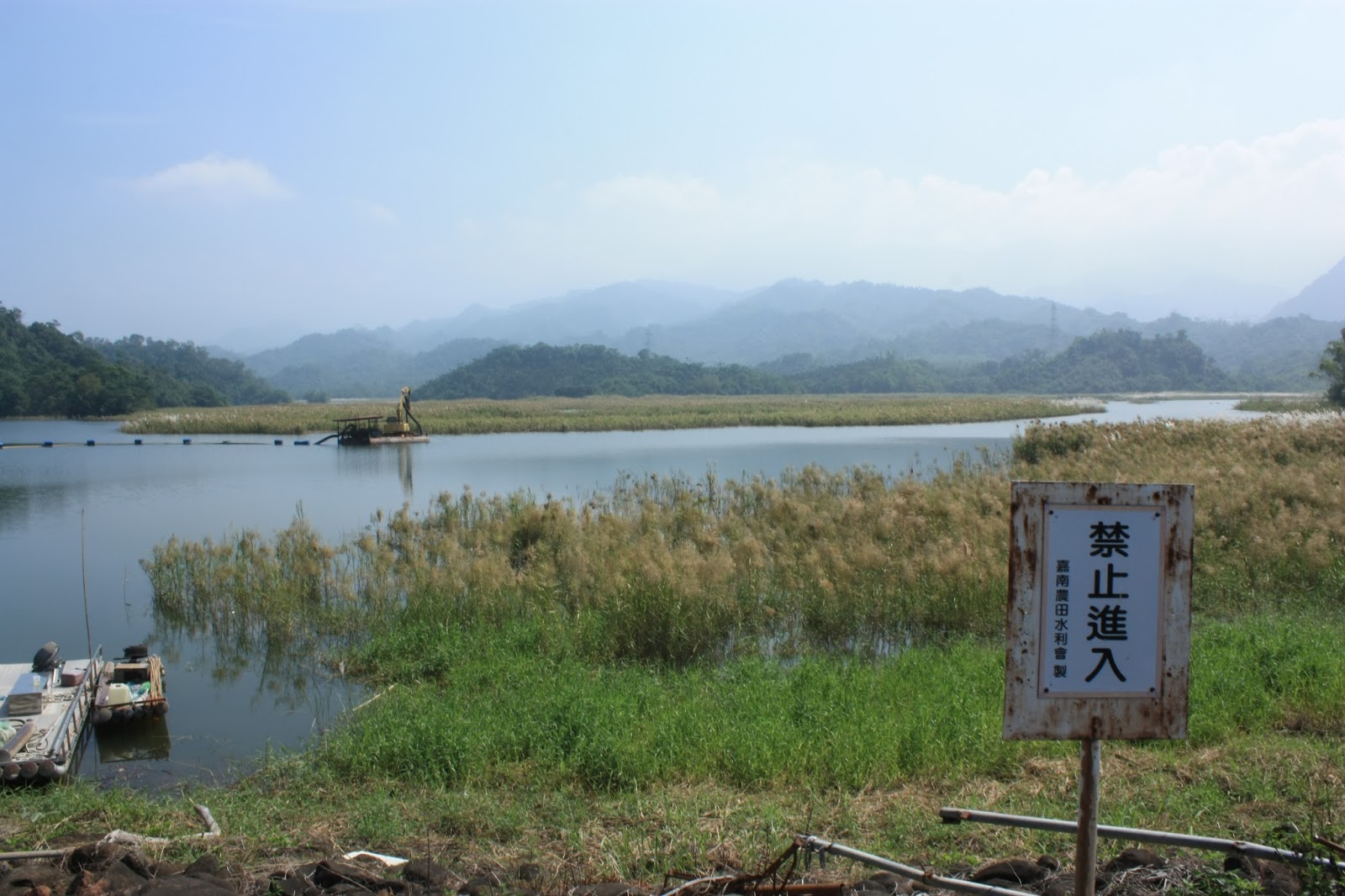
The problem with Baihe reservoir is that its south-west area, which accounts for perhaps 12% of the reservoir's total surface and is the only area visible to the public from the crest of the dam, has been inundated with sediments from its' source river for over five decades. The result has been the degeneration of this area of the reservoir into something of a swamp covered in reeds growing out of the accumulated sediment deposits. During a recent trip with both Ruby and Niki around the north side of the reservoir looking down into the south-west area, I got the strong impression that this stretch of reeds has expanded significantly since last I photographed it properly in 2012 (accompanied at the time by a different Nikki). Below is the photograph I took this past Sunday from the hill directly opposite the dam which lies to the west of the reservoir. It overlooks much (not all) of the south-west area and the expanding reed bed...
 |
| Note the narrow channel of water to the right of the image which runs west to east; the tree covered ridges to the right hide an enclosed channel leading to the north end of the reservoir. |
Compare that image with this one below, which is the same view in approximately the same light but taken back in 2012; although the water level is lower (an incidental detail), the reeds do not yet stretch quite so far and there are instead large areas of mud. The channel on the right is considerably wider and there is a greater expanse of mud (sediments) bordering the reed-bed to the west opposite the dam and spillway...
 |
| The two images are remarkably alike save for the change in the extent of the reed-bed. |
The hilltop from which these images were taken forms a natural boundary between the south-west area and another area on the south side of the reservoir, which has a crescent-shaped harbor fed by a secondary stream just behind it to the east. A farmer's path meanders westward through dense orange and lime groves to bend around the harbor and then undulate up the hill past several christian graves (with crosses made from white kitchen tiles) and then up past the betel nut trees to a narrow ridge from which you can look out westward over the reeds toward the dam. Before we arrived at Baihe reservoir I had stopped at a 7-11 to get myself daubed up in mosquito repellent; Niki declined my advice to do likewise and ended up paying for that decision in mosquito bites on that little path. There are several barrels of standing water along the way from which clouds of mosquitoes arise as you pass by.
The narrow ridge at the top of that hill offers precious little room to move around in with which to vary the angle of shot (I would have liked to have taken similar shots from further south and further north). That being the case, I took a couple of telephoto shots focused on the spillway gates in the distance. I don't think I have ever seen the water level at Baihe reservoir quite so high as it was last Sunday...
 |
| A telephoto shot of the spillway gates; the water is almost as high as the gates themselves, indicating that the reservoir is full at its' present (much reduced) capacity. |
Having taken those shots overlooking the south-west area from the east with the sun behind us, we headed back down the farmer's path to return to the motorbike. I now wanted to drive west around to the front of the reservoir and take pictures of the south-west area looking out from the crest of the dam itself. On the way down we crossed the chief source river and stopped for photographs. Niki was intrigued by a heron perched on a rock in the river downstream from us...


The reservoir is actually fed by two rivers, both of which enter to the south, rather than the east which is usually the case elsewhere at other reservoirs in Taiwan. The smaller of these two rivers does not seem to have a name, whilst the larger of these two is simply called "white river" (or "白河" ["baihe"] in Chinese). It is a relatively short and narrow water course with a total length of perhaps two or three kilometers before it enters the reservoir (a judgement I make by making inferences from google maps rather than from tracing the river on foot myself). Here is a view from the same bridge looking upstream with the hills in the distance...
 |
| Like many rivers in Taiwan, certain stretches of the Baihe river's contours are partially protected from erosion by rip-rap walls and concrete weirs of various design built to slow down the flow of the water. |
 |
| Looking downstream as the Baihe river proceeds toward the reservoir. |
It was a short drive around to the parking area which lies on the reservoir management premises. From here visitors may walk across the premises and then across the crest of the dam where to one's right is the view overlooking the south-west area of the reservoir. An odd thing about the reservoir premises is that there are no buildings housing any kind of displays or exhibits to inform visitors about the reservoir and its history or construction. Back in 2012, the management staff went out of their way to provide me with photocopies of much of the historical information I need - but this was merely an act of typical Taiwanese kindness, rather than a policy as such. There is instead however, a building which houses the headquarters of the Siraya National Scenic Area; a government organization which promotes tourism in areas of Taiwan's countryside formerly populated by the Siraya aboriginal tribe. It is an odd arrangement.
 |
| View through the 18mm lens directly eastward across the reed-swamped south-west area of the reservoir toward the hill (center-right of the image) where we had been taking shots earlier. On the other side of that hill is the little crescent-shaped harbour and the entry point for the second, smaller river. |
 |
| An excavator stationed on a pontoon and accompanied by a generator with a suction pipe floated out across the water to climb over the dam; this is the extent of the dredging operation at Baihe reservoir. It is just enough to keep the reservoir operational, but far short of the scale of work which would be necessary to clean it up properly. In the background the gap between the two hills contains the passage through to the reservoir's northern side. |
 |
| Another view out from the dam toward the hilltop we had climbed earlier that morning. |
 |
| Looking south-eastwards toward the river's entry point into the reservoir. The reed bed just in front of the dam is indicative of how far the reservoir has been allowed to deteriorate over the last four years; in 2011, this was all water, and there were no reeds in front of the dam at all. |
 |
| Looking back south across the dam crest. There was some kind of odd religious ceremony taking place at the time. The mountain in the background is "pillow mountain", which marks the location of the Guanzihling hot springs area by which Tainan's Baihe district is better known. |
 |
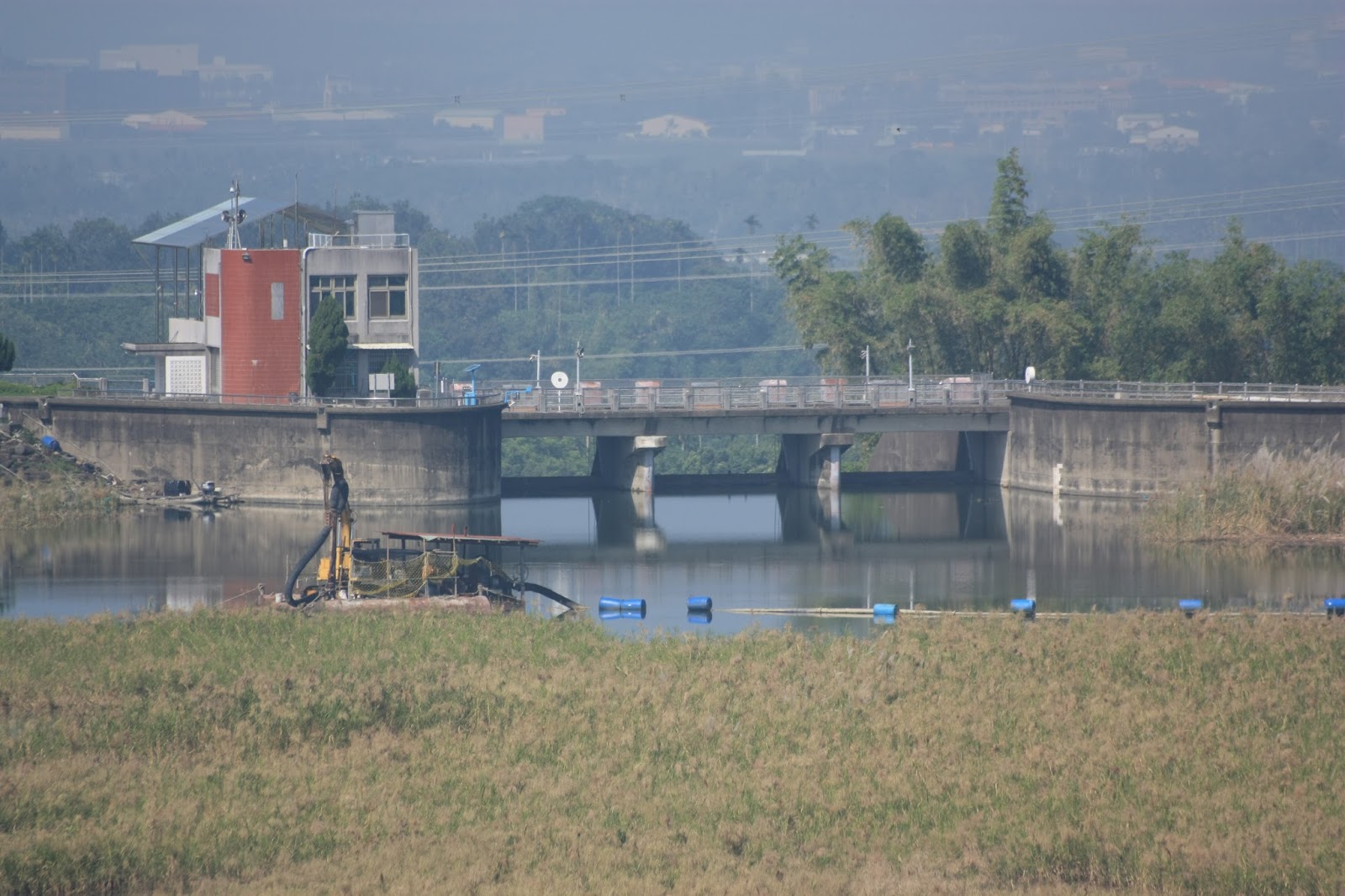
| Looking straight ahead northward toward the spillway control station. The reeds to the right of this image were entirely absent as recently as four years ago. Then, it had all been water. |
 |
| At the northern end of the dam looking directly eastward with the excavator in the background. Fishing is illegal at the reservoir, but is nonetheless a commonplace activity, demonstrating that the southern Taiwanese possess a common sense not always readily apparent elsewhere in the country. |
 |
| Another view out across the south-west area of the reservoir. |
 |
| The spillway control station now has a new steel framed roof structure behind it which wasn't here a year or two ago. |
 |
| Looking back south from the north end of the dam. |
 |
| Arguably the best view of the morning. It used to be all like this once upon a time. |
 |
| The three tainter gates for the spillway; note the water slipping through underneath and the driftwood floating just behind the gates; the water is as high as it can get. |
Having squandered plenty of time at Baihe reservoir we left with the intention of driving up Pillow Mountain to take a quick break for drinks before joining the Tainan 175 southward. This road is also known as the "Dongshan Coffee Road" for self-explanatory reasons; it passes from Baihe district through Dongshan district where coffee is farmed. There are a number of elaborately designed, local coffee stops along this road though I've never stopped at one as I'm usually on the clock when driving this road. It was the same again on Sunday. It's a pleasurable road to drive on which eventually brings you out onto the 174 which snakes around the hills at the back of Wushantou reservoir and winds its way south east toward Nanxi district and Tseng-wen reservoir. Instead of taking the left turn direct to the toll-station entrance for Tseng-wen reservoir we turned right to circumvent the premises and switch onto highway 3 which leads up to the south end of the reservoir and on along its eastern shoreline to the village of Dapu. It had reached mid-afternoon by the time we reached the viewing area facing the distant dam and the air was very humid. I took some shots looking toward the new sluiceway construction though there wasn't much to see.
 |
| Looking down from the viewing area to the eastern shoreline of Tseng-wen reservoir; the water level was so high that it had flooded shoreline roads built for the local farmers. |
 |
| The site of the new sluiceway construction to the left and the water intake tower to the right. |
 |
| As at Baihe reservoir the water level had reached such a height that it was now being held back by the tainter gates for the spillway. |
We drove on to the back of the reservoir and stopped for a short while at a small hamlet for drinks. My main purpose was to visit the construction site south of Dapu to see what was what, but I also thought it would be worthwhile to point out to Niki the driftwood barrier and the large weir northeast of Dapu along the river. Eventually we passed Dapu village and stopped at the construction site for the driftwood barrier, but there wasn't much to see as the river had almost swallowed the structure whole...
 |
| The Tseng-wen river coming down from Chiayi's Alishan district. The water is probably a good five or six meters deep. |
 |
| On its way westward into the reservoir around the next bend. |
At the end of the bridge, we turned right and drove uphill to visit the weir. I was pleasantly surprised to discover that the previously unpaved, stony sections of this road had now been properly treated with tarmac. It is a very short drive from Dapu bridge to the weir, but it does allow you to an even earlier distraction...
 |
| The most popular waterfall in the area because it is easily accessible, unlike the one at Dadi Gorge and the monster behind Nanhua reservoir. |
 |
| The large weir with a muddy Tseng-wen river flowing over it; adjacent to this weir (and just out of shot to the right) is another tributary stream which Niki pointed out was clear and unmuddied. That stream will become very important soon as it is to be the vehicle by which water is diverted to Tseng-wen reservoir from either the Cishan or Laonung rivers high up in Kaohsiung county. |
Having shown Niki the waterfall and what may be the second largest weir in all of Taiwan, we went back the way we had came but instead of crossing the bridge back to Dapu, we headed on up highway 3 to get to the ridge overlooking the driftwood barrier to let her get a better view of it...
 |
| That the driftwood barrier can be almost entirely engulfed by the river has long been a source of frustration for me; why didn't the Water Bureau designers specify a greater height? Note also that the foremost tower is a lighter shade of grey than the one behind it; it was only finished recently whereas the other tower and anchor block have been sitting around for a few years waiting for drought so that their counterparts could be constructed (which occurred at the beginning of this year). |
 |
| The driftwood barrier in perspective; Dapu bridge is just visible in the background. This has long been one of my favourite views and I've taken many shots of it previously. |
We left the ridge over the river (which as I pointed out to Niki has recently been treated with drainage pipes and a concrete jacket to protect it from earthquakes and landslides) and drove back to Dapu where we stopped for another break in the 7-11. After that we went on down to the construction site just to the south but because the water level was so high, the approach road was flooded and we couldn't get near it. Instead we stood some fifty meters or so back taking pictures. The site is only partially submerged however...
 |
| The crane stands alone waiting for action when the water begins to recede again; note the huge pipe section standing upright in the background. |
 |
| A close-up shot of the pipe section; in so far as I can surmise, it is the first section of a planned pipeline to transport sediment from the back of the reservoir to the front of the reservoir where it can then be flushed out through the new sluiceway tunnel currently under construction. What the mechanism will be for making sure the sediment enters the pipeline in the first place, I'm not yet sure. |
 |
| A set of generators sit on a metal table suspended on straps from the crane and tied to the trees to prevent swinging. |
 |
| Fish schooling in the flooded gutter that runs alongside the site's access road. |
 |
| Every now and again they would break the surface for air, for reasons presumably known only to themselves. |
Having been given plenty of food for thought by the sight of the pipeline section now standing upright, we left Dapu and headed back south along the reservoir's eastern shoreline. It was now getting on to late afternoon, and I still wanted to visit Nanhua reservoir. A recurrent problem along Taiwan's winding, countryside roads like highway 3 (and especially highway 8 in Taichung) is getting stuck behind a car driven by someone suffering from short-sightedness (almost everyone in Taiwan wears prescription glasses). These drivers are always too slow and breaking long before they enter a bend even though there is no other traffic or other obstacles in front of them. In combination with the frequency of sharp bends, hills and rises along the road, this behaviour makes it especially difficult to overtake resulting in a frustrating, ponderous drone along the road in a lower gear. One way to relieve this is to simply stop and take in the view, which allows time for Mr-and-Mrs-Study-Too-Hard to get away.
 |
| Overlooking the middle of Tseng-wen reservoir; the peninsula to the right is all that now remains of the bay from which I previously launched boating expeditions across to the wild, western shoreline on the other side. The bay is now completely submerged which represents a rise in the water level of perhaps ten meters or so since it reached its lowest point during the drought at the beginning of the year. |
We stopped in Yujing briefly for another coffee to kick my brain back up a gear, and then headed off on the brief drive to Nanhua reservoir. There is a new sluiceway tunnel under construction there which is designed to prevent sediment from building up behind the curve of the mountain spur to the north of the dam. Originally, Nanhua reservoir was designed with two sluiceway tunnels running either side of the spillway to the south of the dam. This arrangement allows for the removal of sediments in the area of the reservoir from which water will be pumped out of the reservoir into the extraction pipe (for delivery either to Tainan city or Kaohsiung city). The new sluiceway will allow for the removal of sediments building up to the north of the reservoir which would otherwise begin to further restrict its' capacity.
 |
| Public notice as to the planned construction of the new sluiceway at Nanhua reservoir. |
 |
| Overlooking the construction site from a nearby viewing platform; the exit mouth for the tunnel has already been built and the tunnel is currently being excavated. On previous trips I have noted the preparation work being done to the mountain slope on the upstream side; initially I mistook this work for soil conservation measures, which is in a sense, funnily enough, what is in fact being done but to the purpose of preparing the slope for the construction of the tunnel entry mouth. |
 |
| A view of how things stood on the upstream side. This shot was taken during a previous trip back in the middle of August, so it will probably look quite different now with some progress having been made since then. |
 |
| A prepared pipe section with a venturi constriction in the middle, presumably to allow measurements of water pressure once it is installed. |
 |
| The tunnel exit mouth; the steel reinforcement ribs can clearly be seen sticking out of the concrete jacket. |
 |
| Wooden box covering for the setting of a section of a concrete culvert. There will likely be several such culverts built to allow for emergency release of water in case of flooding within the tunnel. |


No comments:
Post a Comment
Comment moderation is now in place, as of April 2012. Rules:
1) Be aware that your right to say what you want is circumscribed by my right of ownership here.
2) Make your comments relevant to the post to which they are attached.
3) Be careful what you presume: always be prepared to evince your point with logic and/or facts.
4) Do not transgress Blogger's rules regarding content, i.e. do not express hatred for other people on account of their ethnicity, age, gender, sexual orientation or nationality.
5) Remember that only the best are prepared to concede, and only the worst are prepared to smear.