Shot at about 11am this morning from the view overlooking the center of the reservoir from the east. I was on my way back when I took this shot, having arrived at about 7.30am and spent all morning paddling around on the raft again; I had wanted to confirm my earlier suspicion that a westward corridor through the ridges to the south was the dead-end I had guessed it would be. Previously, I had taken the raft from the little harbour at the eastern end of the reservoir and explored the furthest of the two southern corridors, as well as having gone straight west in a vain search for the passage leading out from the east which would allow me to approach the dam and spillway from the south rather than (as last year) from the north. Here is a briefly annotated version of the google earth shot...

Since I didn't find any passageway last time, I was somewhat confused and since the route from the north toward the dam and spillway is so much longer than the southern route, I decided to eliminate all traces of doubt by examining the one corridor I had previously dismissed but which, as I discovered, was merely the second, and smaller of the two southern corridors...

This is the view on approach to the corridor from the east (taken at about 7.40am); it looks quite narrow and not at all like the large, gaping passageway visible on the google-earth shot which was why I dismissed it the first time. This time I wanted to confirm that I hadn't made a mistake with my map-reading - because it is much easier to explain a corridor that has become narrower or blocked by the encroachment of reeds or bamboo than it is to explain the complete disappearance of a very large passage of water. Yet that is what I am faced with. Here is a view of the bend in the corridor upon entry...

And around the bend...

The dead-end I had expected to find. It turns out this is the corridor just to the south of where the large, gaping passageway on the google-earth shot is. Later on in the morning (about 9am) I came back to this corridor to have a quick look around, and I was surprised to hear something large fall from a height and emit a very loud hissing sound; I didn't get a picture (wasn't quick enough and had the wrong lens attached anyway), but it was some kind of monkey.
Back on the main body of the reservoir and to the right of this corridor (northwards) there is a concave arch (see google-earth shot above), which ought to be followed by the entry to the main east-west passageway. Here is that arch, although because I was directly facing it, it appears flat...

Following on from the arch further to the right (again, northwards), where the passageway ought to open up according to google earth, there is instead another set of ridges - and they look as old as anything else at Wushantou reservoir, covered with trees, bamboo and other greenery...


At the end of this little ridge, visible in the right-hand image above, the landform just keeps on going in a northwesterly direction with no sign whatsoever of a large passageway other than one or two little cul-de-sacs. As I had explored this thoroughly a couple of weeks ago, I decided to quit. On reflection, I think what I really ought to have done was to paddle further back to get a shot that takes in the entire landform, so that I can then annotate it with indications of where that large east-west passage should be. As for explaining its' absence, for the moment I am at a complete loss.
So, convinced that I had found either (a) an as yet unexplained alteration in the landform structure of the reservoir, or (b) a serious inaccuracy in the satellite shot, I decided there was nothing more to do but head back to the harbour. Because the skies were especially clear this morning however, I decided to relax after about 8.30am and give my shoulders a rest, take some landscape shots and wait for the birds to appear - which they eventually did some time after 9am (I had caught sight of one of the Ospreys earlier at about 8.15am, but at too great a distance to photograph). Below are two of about five or six half-decent shots I managed of a Black Kite who, unlike the noisy eagles who always let you know they are there, swept over me in complete silence as if he didn't want me to notice him ...


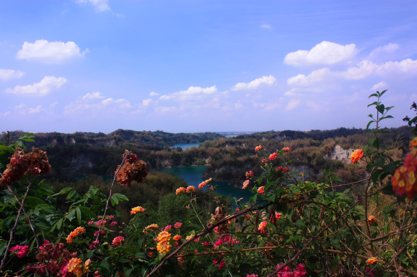
And here is a landscape shot I took looking back southeastwards toward the little harbour. On the other side of those mountains visible on the horizon is the Cishan river valley in Kaohsiung county.

That kite appeared at about the same time as the eagles did, and I have seen both types of bird appear simultaneously before so I'm not sure whether there is any fierce territorial dispute between them; they seem to just ignore each other. Here is the sharpest eagle shot I managed all morning - directly from below with the tucked up legs clearly visible...

And another shot, which although not nearly as sharp, is the one I prefer because of the context provided by the trees below him...

At sometime just after 10am, having spotted that monkey I mentioned earlier on my return to the second of the two southern corridors, I decided to get out of the sun and head back to the harbour (I also had work early in the afternoon, and needed to make sure I got back with plenty of time to spare). So this is a view looking back eastward toward the little harbour...

Visible to the left of this image is another raft paddled by two people - they had been out on the reservoir since before me and we had passed each other by a couple of times but I hadn't given them much notice. They may have been fishing, but they were always so far away from me that I couldn't tell (and I didn't bother to look through my 250mm to find out either). In the distance there is a mountaintop visible on which stand a number of large radio and telecommunication masts; I've driven up there before - it overlooks the "badlands" area of Tianliao district (recently visited by Michael Turton) over which runs a section of freeway 3 after exiting a tunnel. That area also contains the diversion channel running down southwest from the Cishan river to Agongdian reservoir which straddles the Yanchao and Gangshan districts of Kaohsiung.
***
Later...
One possible explanation for why the passage appears to be missing occurs to me; error. From the google earth shot the landform following the arch goes through a 90 degree angle straight down, but in situ it appears to form a north-westerly diagonal at maybe 45 degrees. This apparent difference may be due to perspective. In this aerial photograph below (someone else's I've borrowed from google and which I've annotated), the passage through to the west does seem to be clear...

There is another problem. When I first went out there a couple of weeks ago, we stopped and headed back having seen what appeared to be a dead-end running up against the head of the peninsula to the north and west of our position. Indeed, although I didn't photograph the "dead-end" at the time (believing that I had made a navigation error), I did take this idle shot looking directly down the minor peninsula corridor toward a small hamlet there, which shows just how far west we were...

So what if the dead-end was only apparent, and there is in fact a sharp westward turn that had remained out of sight because I had decided not to waste any more energy? It might be that a combination of perspective-induced error and overgrowth of vegetation give the appearance of a passageway having disappeared. That I think might be the more likely explanation and will require another trip to verify.
No comments:
Post a Comment
Comment moderation is now in place, as of April 2012. Rules:
1) Be aware that your right to say what you want is circumscribed by my right of ownership here.
2) Make your comments relevant to the post to which they are attached.
3) Be careful what you presume: always be prepared to evince your point with logic and/or facts.
4) Do not transgress Blogger's rules regarding content, i.e. do not express hatred for other people on account of their ethnicity, age, gender, sexual orientation or nationality.
5) Remember that only the best are prepared to concede, and only the worst are prepared to smear.