
A friend of mine wanted to come with me again on my second rservoir trip this week - to Baihe reservoir in the north of Tainan county. The first time she came, we merely explored on foot and I took pictures, but this time I wanted to explore further and because there were no more roads and trails to follow, I knew I was going to have to find alternative means...


One thing we hadn't noticed on the previous visit, was that seemingly all of the rafts and their accompanying paddles were chained and padlocked. After a bit of searching, I found a smaller raft tied to a larger one only with rope and so, thankfully, I was able to borrow that one (plus a couple of 4+ meter bamboo shafts to act as makeshift paddles) and manouvre it around to the other side of the jetty to pick up my friend. Leaving my sandals and sweater behind on the shore, I set off barefoot - which proved to be a wise decision - and headed south-west toward the reeds which occupy perhaps more than half of the south-western section of the reservoir. During our previous visit, we had climbed the overlooking hill to acquire the best views westward over the reeds toward the dam and the spillway gates in the distance...

The approach to the south-west of the reservoir with the reeds and muddy shoreline in the distance. At this point, by way of dipping our bamboo "oars" into the water, we could infer that the depth of the reservoir was never more than perhaps a meter and a half...

Before arriving at the reed-infested shoreline however, we checked out a couple of the inviting little cul-de-sacs that opened up into the tree clad peninsula that cleaves the reservoir into northern and southern sections. In this one, we found a floating net (with a couple of dead fish) and this make-shift barge moored up against the shoreline; it comprises two rafts (wider than ours) surmounted by some kind of ad-hoc roofing material. There wasn't time to enquire further...

Below is a shot looking back eastward to the way we had came; the raft jetty is around the corner off to the right. Notice the shoreline of reeds in the distance; they form the eastern bank for the second (smaller) of Baihe reservoir's two tributary rivers...

A few specks of dirt on my lens somehow went unnoticed at the time, unfortunately. In the image below, the south-west reeds are immanent. Note the measuring pole sticking out some three meters or so above the surface; there were several of these posted along the reservoir at various points.

Another view looking back eastward with one of the make-shift "oars" in view - actual paddles would have made things easier of course, but I found the paddling nowhere near as hard as I had expected it to be...

Having tethered the raft to a piece of driftwood I drove into the mud as an anchor, we trod deep footprints across the moist mud. Being the heavier of the two (my bathroom scale is broken at the moment, but I guess I am somewhere around the 170-180 pound mark), I would occassionally sink into the mud up to my knees.

Standing at the edge of the reeds, with the reservoir's spinal peninsula to our right, we could gaze straight across the mud-flats toward the dam and the spillway gates on the westward horizon...

Further westward, we turned right at the base of the reservoir's spinal peninsula to look northward into the north-west section of the reservoir - the mud-flats extended some twenty odd meters westward at this point, but only on one side; the westward side of the gap allowed water to move between the northwest and southwest sections of the reservoir. I suspect however, that any movement of water would most likely be northwards away from the dam, spillway and - more importantly - the two underwater pumps (one for the irrigation channel, and the other for the water treatment facility in nearby Dongshan district). Two reasons for this: first, the two rivers that feed Baihe reservoir enter to the south, meaning the incoming water will naturally be headed northward anyway, and second (as I was later to confirm) I suspected that the northern section of the reservoir would be a lot deeper than the southern section. This may either be due to a slope in basin topography from south to north, or is simply the result of the build-up of sediment in the southern section over a long time.

Seeing as we were stuck (with our raft moored behind us across the mud flats), and with walking into the reservoir's northern section being an obvious impossibility, my eye was naturally drawn immediately to another raft moored some way across from us in a section of shallow water approachable only by wading through squelchy, knee-deep mud. Which is exactly what I then did...

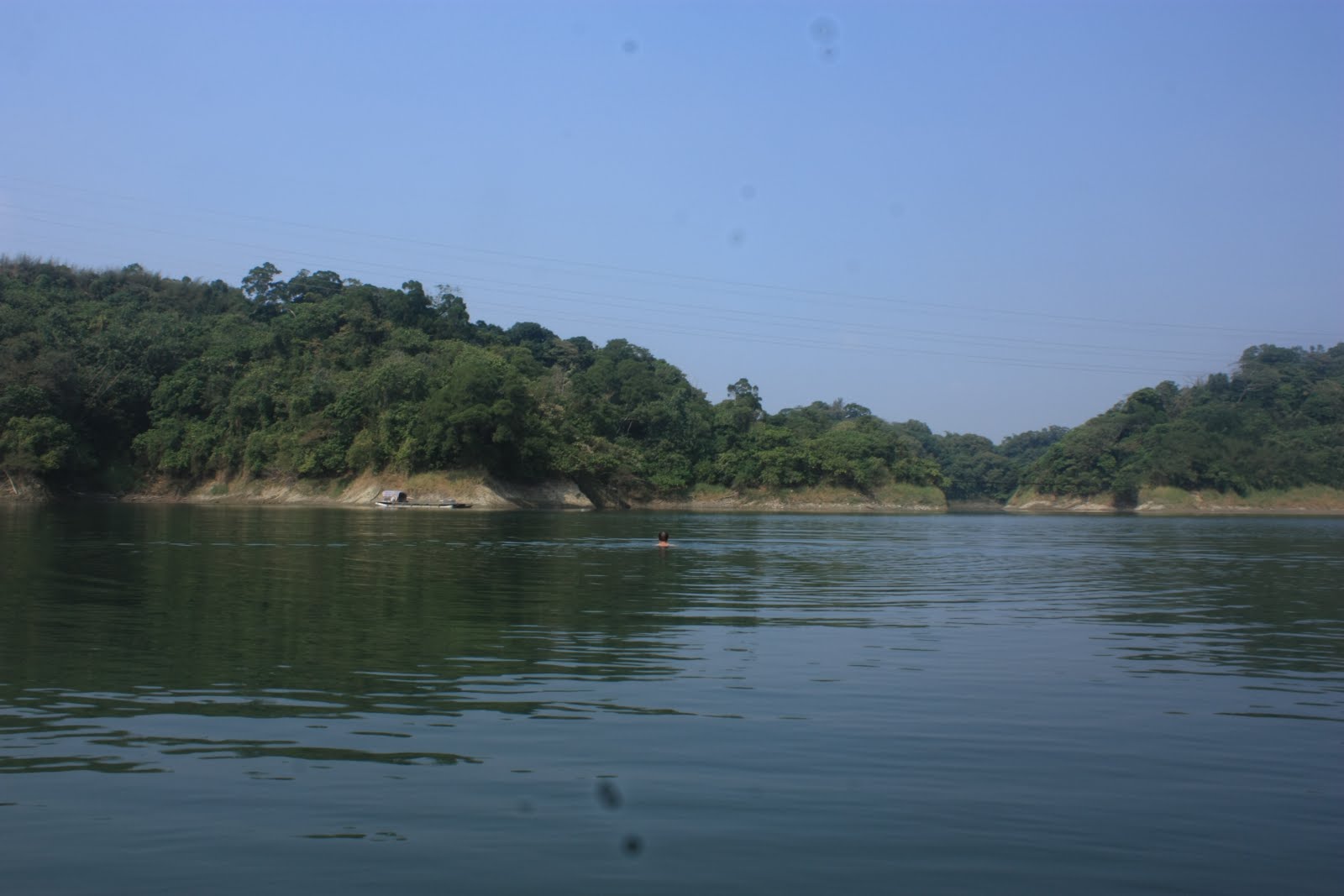
Having taken command of a new, much larger vessel (also equipped with a 4 meter bamboo pole to use as a paddle), I pushed us out well into the northern section and had to stop for a breather. Dying to see what was around the corners of this section of the reservoir, I decided to get ahead by swimming. This image below is probably the best one she took with my camera (although the 250mm would have been better for this kind of shot)...
Around the first corner to my right was the central channel on the northern side of the reservoir's spinal peninsula which leads all the way up into the north-eastern section just over a kilometer away to the east. I decided not to paddle all the way up that channel this time, because I wanted to see what a certain black line was straight ahead of us to the north.

I had guessed that that line had been a footbridge rather than a water cable, and I was right; the water cables for remote areas like this usually droop slightly in a similar manner to electricity cables. This was straight, not drooping, so it had to be a bridge. The footpath on either side of the bridge appears to have long since fallen into disuse and has been returned to a state of nature.

Just before passing under the bridge, we gazed at the final eastward expansion of the reservoir; after this point the reservoir curves around toward the east to meet its' end. And that's where we headed - that eastward expansion does not, according to the map, meet up with the central channel heading out to the eastern section of the reservoir.

Crossing under the footbridge; the cliche of missing wooden planks wouldn't necessarily render the bridge useless as it may still be possible to walk across the cables....

After crossing under the bridge, the reservoir bends eastward for its final stretch. So as not to waste effort pushing all the way out there only to find nothing to photograph, I jumped back in the water and swam ahead. Aside from two long since sunken boats, I found nothing by the time I reached the dead end - whereupon one of the crested serpent eagles we had been hearing all morning was disturbed by the noise of my approach. I had a great view of her taking off, but obviously no camera with me to do anything about it. So at that I swam back to the raft and we made our way back the way we had came with me pushing much harder and faster than before to save time. After mooring that second, larger raft and taking up again on our first, smaller raft, we paddled back out across the southern section of the reservoir eastward toward another mud-flat - visible in the picture below (taken from the small hill above the raft-jetty)...

After mooring the raft and crawling through the mud again, we got up onto the drier section of the mud-flats to find the gap in the small escarpment locking away the eastern-most section of the reservoir. On the other side of that gap the reservoir splits into two fractal channels, each with many of their own break-away channels and cul-de-sacs.

I swam across to have a quick look around and was joined several times by a small number of fish leaping out of the water only a few feet away. Of course, swimming meant I could see what was on the other side, but could not take any pictures. So I'll have to solve that problem somehow next time...

With the weather being forecast for rain all this week, it may be some time before I can get out to explore Baihe reservoir again. And there are plenty of other things to do too, including taking a trip down into Kaohsiung to see the little Fongshan reservoir, which confusingly, is not actually in Fongshan district at all, but in Xiaogang district.
No comments:
Post a Comment
Comment moderation is now in place, as of April 2012. Rules:
1) Be aware that your right to say what you want is circumscribed by my right of ownership here.
2) Make your comments relevant to the post to which they are attached.
3) Be careful what you presume: always be prepared to evince your point with logic and/or facts.
4) Do not transgress Blogger's rules regarding content, i.e. do not express hatred for other people on account of their ethnicity, age, gender, sexual orientation or nationality.
5) Remember that only the best are prepared to concede, and only the worst are prepared to smear.