


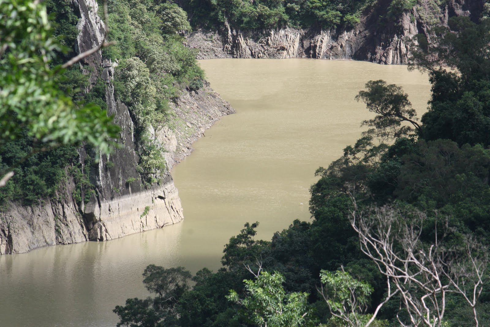
 Overlooking the eastern spur of the small aboriginal village of Shihmen (石門) in the south of Pingtung County just before the Hengchun (恆春) peninsula, Mudan reservoir is approximately an hour's drive north from Kenting (墾丁), a popular beach resort, at the peninsula's tip. Located mid-way between the west and east coasts, Mudan reservoir also sits at the base of the island's mountainous spine. Completed in 1995 just two years after Nanhua reservoir up in Tainan, Mudan reservoir was built in order to meet rising demand for fresh water in the Hengchun peninsula following the government's efforts to encourage the development of tourism there with the establishment of the Kenting National Park (墾丁國家公園) in the late 1980s and the construction of the National Museum of Marine Biology & Acquarium (國立海洋生物博物館) during the 1990s. With a surface area of just 1.4 square kilometers, and a designed capacity of 30 million cubic meters, Mudan reservoir is one of Taiwan's smaller reservoirs. Supplied directly by two principal rivers, one to the north, and one to the east, neither of which passes through a filtration system, Mudan reservoir has suffered in recent years from over-sedimentation following several episodes of intense rainfall. Presently, however, the reservoir is in a relatively healthy condition following a major de-siltation project carried out by the relevant authorities following Typhoon Morakot in 2009. From a reading of the early June 2012 hydrological data provided by the WRA in which it is stated that the water level is just 9.43 meters below the maximum level, it may be surmised that there is an additional 13.4 million cubic meters of water which the reservoir can take*. Given that the WRA hydrological data summary also states that the reservoir is currently withholding a volume of 15.9 million cubic meters, then that would mean Mudan currently has an effective capacity of 29.3 million cubic meters, or just over 97% of its designed capacity.
Mudan Reservoir Dam & Spillway


 Once free from the close proximity of houses and school buildings that line the nearby road, all first-time eyes will naturally find their gaze drawn northward up toward the spillway gates in the top right hand corner of Mudan reservoir dam. Standing across the headpoint of Shihmen village at a length of four hundred and forty five meters and a height of sixty five meters, with roads slinking away up into the mountain shoulders to either side, the dam dominates the entire valley lying below it. This effect is strongly augmented by the deep and broad channel lying at an angle perpendicular to the dam's east-west axis, and coursing southward at the behest of the visually commanding spillway gates above it. At the approximate centre of the downstream face of the dam there is a concrete staircase ascending to the crest. Strangely, this staircase is the only public access point, since, although there is also an access road running under the spillway and winding its way up the western side of the dam, the general public are prohibited from using it. No reason appears to be given for this**. Like many, though not all, of Taiwan's reservoirs, the public information panels present at Mudan reservoir are few and far between and contain scant information. Nowhere, for instance, did I see any basic information regarding the layout and composition of the dam, let alone any documentation of the period during which it was constructed between 1989 and 1995. Simple observation alone however, would suggest that the dam is built upon a single clay core since the downstream face of the dam forms a single tier, rather than two tiers as at Nanhua reservoir. According to the Pingtung County government's website, Mudan's dam is an "earth-dam", which would seem to suggest that the semi-permeable shell buttressing the central core on the downstream side is likely composed of some mixture of loam and gravel or perhaps sandy loam, rather than loose rock-fill as at its contemporary further to the north in Tainan. From its eastern point above the spillway, the crest of the dam runs along a distance of over four hundred meters before, at its western extremity, banking to the north for a further two hundred meters or so before culminating in an escape chute control station which has an accompanying depth index; the stain on the upstream face of the dam marks the maximum high-water level at which water must be drained from the reservoir in order to prevent the build-up of excessive pressure against, and seepage of water into the dam.

 In the design of its' spillway, Mudan has elements resembling the spillways of both Nanhua and Tseng-wen reservoirs up in Tainan - the initial stilling pool resembles those at both of the above reservoirs, whilst the three hydraulic gates at the top are very similar in appearance to those at Tseng-wen though obviously much smaller, at perhaps ten meters tall as opposed to the thirty meter tall gates at Tseng-wen. Most interestingly, the shape of the spillway itself somewhat resembles that of Nanhua's spillway in that it undulates in three slopes out across from the dam by a distance of perhaps forty meters. The first of these two slopes are relatively gentle and end in a shallow depression prior to the final slope over which the water falls into the stilling pool below. As at Nanhua, a road runs underneath this third slope, although in this case the downstream face is no mere concrete wall but actually a set of eight arches that would afford a close-up view of the overflowing water during operation of the spillway. The design of the spillway, and the shallow depression prior to the final slope in particular, prevents the outflowing water from accelerating too much under its own weight and therefore the excess water will flow out from the reservoir at a slower rate than if the spillway had been a straight forty five degree chute (as is the case, for example, at Shihmen reservoir [石門水庫] up north in Taoyuan County). In consequence, it would seem that Mudan's spillway is capable of displacing a given volume of excess water at a rate of flow comparatively much slower than that at other, larger reservoirs which use a straight forty five or thirty degree slope. The importance of displacing excess water slowly is to aid in preventing the relatively narrow water course further downstream from the reservoir from bursting its banks during periods of sustained heavy rainfall.
Mudan Reservoir Lime Filtering Station?


 To the immediate south of the dam's centre-line - marked by the public staircase - there is what appears to be a water pre-filtering station housed inside a relatively small, flat-topped rectangular building. The station is fed on its eastern side by a blue pipe of perhaps fifty centimeters in diameter running out diagonally from underneath a rocky knoll abutting the eastern side of the dam. The water then exits the station in two ways; some of the water is piped underground toward a full-scale water treatment plant one and a half kilometers to the south-west whilst the remainder exits from a sideways slit in the house to spill out into an escape chute. Since the building is relatively small and the nearby instrumentation panel gives a voltage reading of only four hundred volts, it may be that what takes place inside the station is simple water electrolysis, with the likely alkali-rich water piped in from the reservoir a potential source of lime. Assuming membrane electrolysis is what takes place in this building, then the resulting alkaline solutions forming around the anode would presumably be pumped underground toward the water treatment plant downstream where they could be further separated into their component compounds and some of them (especially lime) used to aid in the sedimentation stage of the water treatment process. The water solution forming around the cathode and separated from the alkalines by the membrane, could then exit the building through its side-slit and pour out into the escape chute and thereby return to the river before drawn into the water treatment plant a further kilometer and a half downstream. This is what I surmise the building is for largely because alternative functions make little sense; it is far too small to house any major flocctuator or sedimentation basin and it almost certainly does not house a small hydroelectric generator; the absence of a transformer station and the accompanying transmission cables hooked up to pylons testify to that. (See update below...)
Mudan Reservoir Monitoring Facilities

 From the eastern extremity of the dam crest, just prior to the spillway gates and the control station on the other side, the eye is naturally drawn out further eastwards toward the inlet for the reservoir's eastern feed river. Prefacing this view to the bottom right, and just below a staircase leading up to the control station, is a floating rubber-mat platform at which four small vessels are moored. Furthest from view is a small, open air motor boat with a hull of approximately only four meters in length. Immediately next to that vessel is a significantly larger boat with a hull of perhaps six meters in length, a roofed cabin and a sizeable outboard motor (maybe 100 hp or so). The larger size and power of this vessel may indicate that it is intended for policing the reservoir and the outer extremities of its two rivers from possible poachers. However that boat would very likely be too large to navigate any considerable distance upstream into the shallows of the northern river; for this purpose, there are two smaller vessels moored closer to view: an inflatable dinghy and a typical Taiwanese pipe-raft with a small outboard motor attached (similar to, but somewhat wider than, the one I used at Wushantou reservoir). These smaller vessels would be ideal for gathering water samples from different areas of the reservoir as well as the river shallows further upstream.
 On the opposite side of the reservoir to the west, there is also a draw-off tower built into the dam itself, the staircase of which is adorned on its southern side by a water level index. From this tower, water can be pumped out beneath the dam either through an emergency escape chute, which finds its exit just prior to the lime filtering station, or possibly through a pipe running at a diagonal south-eastwards before making a switchback to enter the lime-filtering station. However, although the first of these suggestions seems very likely to be true due to the relative positions of the draw-off tower and the exit for the escape chute angled north-westward and running beneath the dam, the lack of publicly available information on the design of Mudan reservoir makes it difficult to either falsify or confirm the second conjecture. Certainly, it is common for rock-fill and earth-fill dams to have emergency escape chutes running beneath the dam as at Nanhua reservoir to the north in Tainan, but constructing a pipe to run a total length of perhaps five hundred meters and switching back on itself halfway at a ninety degree angle would be an extremely inelegant design.
 North of the western draw-off tower, there is a small, shaded recreational area with a little Taoist temple and signs of occassional habitation (including, curiously, an onion bag filled with snails dumped in the shade of a bush). The road through this area terminates at the end of a brief concrete ramp of perhaps fifteen meters in length. Interestingly, this ramp is accompanied by what seems to be an electrical ladder winch for pulling up small loads from the reservoir some ten meters below the end of the ramp. Although the ladder's feet are fused into the concrete ramp, the power source for the winch is obvious - a small, solar photovoltaic cell mounted on a plinth. The presence of the winch would seem to suggest that this is a legally designated area for a certain amount of fishing every year, and this is supported by the presence of fishing boats in the reservoir just below the sheer drop down. The erosion of the cliff-face in this relatively secluded western alcove of the reservoir may have been caused by landslides following heavy rainfall.
The Geography Of Mudan Reservoir


 Fed by two rivers, one entering the reservoir from the north and one from the east, Mudan reservoir is at risk from over-sedimentation due to the fact that each of these rivers meanders its way through mountainous and relatively inaccessible terrain for several kilometers. For most of its length, until perhaps a kilometer or so before it enters the reservoir, the eastern river is a shallow, fast moving stream set in a deep gorge running in more or less a straight line from north-east to south-west. Any run-off of sediment from the mountains that shape this gorge would therefore quickly make its way downstream toward the reservoir, and indeed, this seems to be the case - following a recent period of heavy rain the river was a silty, greenish-brown in its broader, deeper stretch as it rounds a mountain spur prior to entering the reservoir. At no point as it approaches the reservoir does the eastern river pass through a weir or any other artificial barrier designed to slow it down; the contours of the mountains immediately bordering the reservoir perform that function, but far too late to aid in the deposition of sediment further upstream. Provincial highway 199 runs approximately parallel to the eastern river from atop a cliff overhanging the gorge in which the river flows, and leads the driver north-east up into Taitung County (台東縣) on Taiwan's Pacific east coast.


 Unlike the fast-moving eastern river, the northern river enters Mudan reservoir after following a slow, meandering course of perhaps two kilometers or more. And again unlike the eastern river, the northern river has no provincial highway to track its course. Instead there is only a narrow, poorly maintained access road marked with potholes and broken up boulders from previous landslides. At a distance (as the crow flies) of approximately one and a half kilometers from the point at which it dissolves into the reservoir, the northern river passes over what appears to be a specially designed double weir system. The first weir is augmented on the downstream side by a series of seven stout "teeth", each with a span of perhaps two meters, that leave eight gaps through which the water must pass after flowing over the weir. Subsequent to these "teeth", the purpose of which must surely be the dissipation of energy during floodwaters, the water passes into a short weir pool before flowing over a second weir featuring a small V-notch in the centre. Immediately downstream from this second weir, there is a somewhat irregular series of baffling blocks with minor escape channels to either side. This elaborate drop-structure seems to have been built for three purposes; first, dissipating the energy of exceptionally large floodwaters; second, slowing down the flow of the river during normal, sub-critical flow velocities in order to allow more sediment to settle upstream rather than downstream in the reservoir itself; and third, to have the auxilliary effect of preventing further erosion to the river bed and valley further downstream. Perhaps half a kilometer further downstream the broken remains of another weir can be seen from the eroded cliff-side above the river. This structure can still be seen in its former, complete form in the corresponding satellite image for the area on Google Earth, which, aside from indicating that the GE satellite images for this area are now at least several years out of date, means that the new weir further upstream must be a relatively recent addition to the river. The river valley in which the former weir sits shows signs of heavy erosion; the cliffside is covered in bare shale and is now propped up by curtains of corrugated sheet metal between iron girders, which might indicate a previous landslide following heavy rainfall. Furthermore, the point at which the river makes a U-turn in the satellite image just after the site of the former weir has now morphed into a fully formed ox-bow. The obvious conclusion to draw is that what we are looking at here are the consequences of Typhoon Morakot in 2009, which brought with it the heaviest rainfall seen in southern Taiwan since records began. If that is in fact the case, then it would mean that the new weir further upstream was likely built sometime during 2010 after the clearing of the site of the old weir. However, given the seemingly precarious means by which the cliffside is propped up, it is likely that the area remains vulnerable to the effect of heavy monsoon rains or typhoons, and that the reservoir continues to be at risk of future over-sedimentation.


 To the south of the reservoir, the Mudan river tumbles out through a distance of over eleven kilometers (as the crow flies) toward its delta on Taiwan's south-west coastline. For the greater part of this distance, the banks of the river are protected with concrete levees and accompanying culverts to drain off excess floodwaters, however, in its broader state as it nears the delta, the river sits within the natural, unprotected contours of its channel. At about two-thirds of the river's distance downstream from the reservoir, there is another dock and weir system intended to retard the flow velocity of the river in order to protect the natural channel from flooding and erosion further downstream. The weir system itself is actually a series of three weirs forming two shallow weir ponds of perhaps no more than thirty centimeters deep each. The first weir is approximately one meter in height and is slightly odd in that it seems to be split in two; the western half of the weir appears to be broad-crested, meaning that the water's head remains in contact with the downstream face of the weir as it overflows, yet the eastern half of the weir seems to be sharp crested, such that the water's head "jumps" cleanly over the weir into the pond below. Whether this is by design or a curious accident of erosion resulting from the build up of debris behind the weir altering the water-head's flow characteristics is unclear. However, on the eastern side of the river there is another oddity: a concrete chute supported by several pillars and set at a very gentle downward incline of perhaps five degrees which carries water over the weir system only to be returned into the river some forty meters further downstream. The obvious inference to draw is that this chute is a slightly unusual kind of fishway, i.e. a passage designed to allow freshwater fish to swim upstream in spite of the weir in order to spawn in the shallower waters further upstream. Whether it is a successful design or not is unclear, but I didn't see any anglers on the river either upstream or downstream. On the western bank of the river, a dock gate funnels water into an irrigation channel which runs parallel to the river for some distance before disappearing underground to pass beneath the main road (199). To the west of that road stretching northwards, a number of onion farms lie spread out between the mountains and the often wind-swept coast. Along the main coastal highway (26) heading northwards, onion vendors selling bags of red, white or brown onions (usually in two sizes) are common. Since Taiwan has a hot and humid sub-tropical climate, it may be that the typically windy conditions along this stretch of Taiwan's south-west coastline help to vernalize the onion seed-stalks during the winter (i.e. reduce both temperature and humidity), which may explain why onions are such an obvious cash-crop for farmers living along this stretch of the coast.
***
Like the other reservoirs in southern Taiwan, Mudan reservoir has much to offer the inquisitive visitor and certainly more than would meet the eye of the merely casual visitor whose visit begins and ends at the entrance gates. However, because Mudan reservoir is a good two to three hour drive away from the nearest large cities (Kaohsiung and Tainan), and because public access to the dam is restricted to those on foot and because the publicly available information is so sparse as to verge on the non-existant, the reservoir is unlikely to draw much in the way of tourist traffic.

*According to the latest hydrological data (June 2012) provided by the WRA, the reservoir is currently operating at just over 50% capacity, withholding a water volume of 15.9 million cubic meters behind the dam. However, since the water level is currently just 9.43 meters below the maximum level, that means there is an additional 13.4 million cubic meters of water which the reservoir can take. Putting those two numbers together and subtracting them from the maximum volume of 30 million cubic meters leaves a volume of about 700,000 cubic meters (or just over 2%) which is presumably all sediment at the bottom of the reservoir.
**The walk from the carpark to the dam itself and then up a 200 foot flight of stairs can be uncomfortable, especially on a hot day with temperatures in the high 90s (i.e. >30 degrees celcius), so the reservoir is not a day out for pregnant women, or the elderly and frail.
Update:
My earlier conjecture is wrong - the building in front of the dam fed by pipe doesn't do anything more than simply divide the water supply from the reservoir into two flows: the first exiting the side of the buidling into the open river is for irrigation, and the second, which is pumped through an underground aquaduct the short distance south-west to the treatment plant is simply raw, untreated water. The building's small electrical supply is enough only to control the valves.
nice work
ReplyDeleteMerci ! C'est impressionnant. C'est un travail digne d'un « A ».
ReplyDelete