 |
| Looking downstream on the Zhuoshui river bed from the 71 bridge in Wuchieh village. In the distance a concrete arch bridge spans the valley to shoulder the weight of an enormous water pipe delivering water to Sun Moon Lake. |
Due to Sunday falling on the 28th February this year (February 28th is usually a national holiday to commemorate the victims of the "228" massacre in 1947), I had a day off work on Monday. I spent Saturday and Sunday relaxed with the dogs, only running minor errands and doing small jobs around the house. On Monday morning, I left with Karen for Ershui township in Changhua county to pick up my motorbike and then on into Nantou county to make a return trip to Wuchieh reservoir up in the hills.
As usual, I didn't get the early night necessary and so struggled to rise and shine in time, not getting up until just after 5 a.m. which meant that by the time I had necked a cup of coffee, showered, changed, walked all the dogs and got my kit together, it was well after 6 a.m. We arrived in Ershui at about 8.30 a.m. and made it into Shuili just before 9 a.m. Without pausing we drove on up the 131, and eventually got onto the mountain ridge above the Wuchieh valley by 10 a.m. and to the east side of Wuchieh reservoir itself shortly afterward.
Wuchieh reservoir has two dams; one to the north and one to the south, both of which can only be partially seen. The northernmost section of the northern dam, which houses the entrapment pen for the original Japanese tunnel, is hidden from the observer on the opposite shoreline by a convex spur of mountain, and the northern half of the southern dam is entirely obscured by a similar interceding thrust of mountain. The purpose of this trip was to get clear views and photographs of the upstream faces of both dams and, in addition, some photographs of the downstream face of the southern dam (the downstream face of the northern dam is hidden inside the mountain with only sluiceway tunnel mouths visible on the other side).
The problem that had to be solved was perspective; on the shoreline opposite the two dams is a road, the Nantou 83 (which runs south-west through a tunnel out to Wuchieh village and becomes the Nantou 71), from which views toward both dams can be had. However, the views toward the southern dam in particular are partially blocked by trees and rushes, and partially obscured by perspective...
 |
| The northern dam at Wuchieh reservoir, partially obscured by an elbow of trees to the right. |
 |
| At the south end of Wuchieh lies a reinforced mountain spur which houses the entrapment pen for one section of the new diversion tunnel; to its' immediate right, and very much obscured by a sloping mountainside, are the tainter gates for the southern dam which is what I wanted to see. |
On previous visits, I had noticed an access road leaving the south end of the 83 and winding its way down toward the shoreline, and this was what I had come to try out; whether better views could be had from somewhere down this access road.
Unfortunately the road leads straight to a locked gate and fence. On the other side of that gate, there is a grass verge backed up against the mountainside from which it would be impossible to see either dam. However, there was also a dirt track leaving the slip road northward through the reeds. We parked and followed this track on foot; for most of its' length the trees and reeds are more than sufficiently tall to block out all views of the reservoir but after a short while it ends in an open area with a dried-up stream bed which in turn leads down to the reservoir. From there, good views were available across the reservoir to the northern dam and the original entrapment pen, but still only very partial views to the southern dam.
 |
| View westward to the northern dam from where the dried up stream bed reaches the reservoir. |
 |
| View westward across Wuchieh reservoir toward the northern dam, taken with the 300mm lens. Beneath the yellow superstructure you can see the steel grille of the entrapment pen for the original Japanese tunnel feeding water to Sun Moon Lake. Above it is a footpath running down the hill from the control house to the top left of the image. I have seen people walking down this, so it might be possible to get a closer view. |
I walked back along the dirt track to the gate to collect my other gear. Whilst I was there I jumped the fence to get a clean northward view of the reservoir from the shoreline. Although my intention was to take several shots and stitch them together into a panorama, I appear to have mucked it up somehow (not sure how yet). That being the case, I just post the original photographs one after the other. I'll repost the panorama if I can be bothered to fix it later...
(What went wrong was the edges; the brightness levels were massively increased out of proportion with the rest of the image and certainly don't match the same areas in the original images).
 |
| Another partially eclipsed view of the gates astride the southern dam taken from the eastern shoreline. |
Anyway the obvious solution to the problem of trying to see the southern dam from the dried up stream bed was to get out onto the water and away from the encumbering foliage of the shoreline to get a clear view. Which is what I did...
 |
| View of the southern dam from some distance; I now know that it has six tainter gates rather than the four I had previously supposed. |
 |
| The same view but taken with a different focal length. I would have liked to have moved closer but, among other minor worries, I was as time conscious as always due to the need to see the downstream side of the dam and the sheer length of time it would take to get back to Tainan at a reasonable hour. |
Once I was out on the water, I took my shots quickly and was back on the shore inside ten minutes. From there, it was a matter of packing up and driving back down to Wuchieh village and the other side of the two dams whereafter the river forms an S curve to bend around the mountains and eventually the village. The plan was to cross the suspension bridge and then jump the fence and wander down to the river bed and around the curve to the downstream face of the southern dam.
 |
| The rickety old wooden suspension bridge spanning the S curve in the Zhuoshui river before Wuchieh village. |
 |
| And because this is Taiwan and not a health-and-safety-obsessed Western country, there was an old bloke driving a motorbike across it and beeping at the tourists to get out of the way. Actually, because his motorbike is a little Sanyang 125cc (more or less identical to the black one I have). |
Eventually, the tourists stopped taking pictures of each other and the daft bridge and I was able to quietly lob the fence and amble my way down to the river bed and walk straight around the bend to get what I came for...
 |
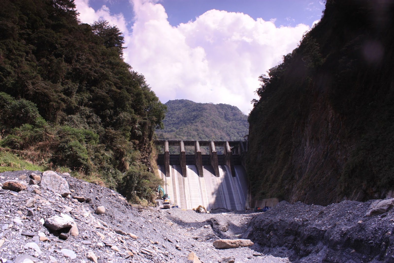
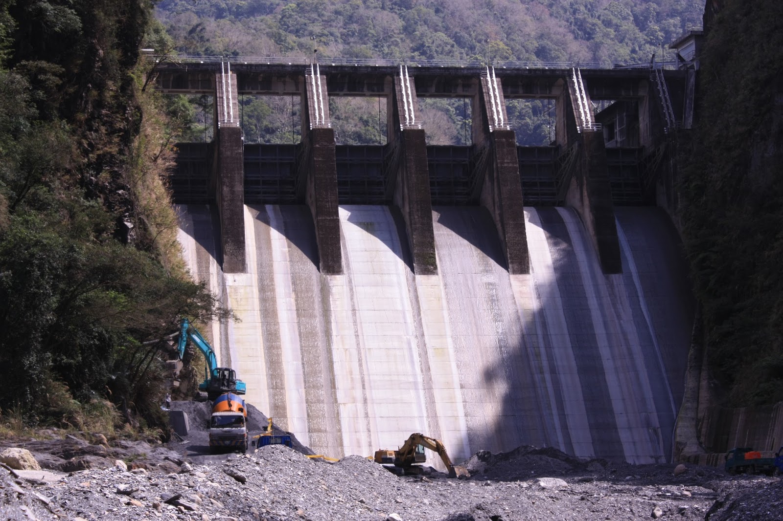
| The downstream face of the southern dam; six tainter gates on top of a spillway slope very similar to the spillway at Mingde reservoir in Miaoli county, if perhaps slightly taller and maybe built at a more abrupt angle. |
 |
| Close up shot taken with the 300mm lens. I suspect the work being done is maintenance work with the possible addition of (or replacement of) concrete retaining walls to prevent soil erosion. That would explain the presence of the concrete mixer in addition to the excavators. |
Thankfully, I got my shots taken quickly and was back up on the bridge in short order with Karen. We walked back to the carpark and then began the long drive back up over the hills and down to the west coast and then back on the freeway down to Tainan.


No comments:
Post a Comment
Comment moderation is now in place, as of April 2012. Rules:
1) Be aware that your right to say what you want is circumscribed by my right of ownership here.
2) Make your comments relevant to the post to which they are attached.
3) Be careful what you presume: always be prepared to evince your point with logic and/or facts.
4) Do not transgress Blogger's rules regarding content, i.e. do not express hatred for other people on account of their ethnicity, age, gender, sexual orientation or nationality.
5) Remember that only the best are prepared to concede, and only the worst are prepared to smear.